Sound Transit's press release on this document
Jump to where this document is posted in the Public Interest Transportation Forum
FOR
CENTRAL PUGET SOUND REGIONAL TRANSIT AUTHORITY’S
(SOUND TRANSIT)
NORTH LINK SEGMENT OF THE
Central Link Light Rail Transit Project
King County, Washington
BACKGROUND
The Federal Transit Administration (FTA), pursuant to 23 Code of Federal Regulations (CFR) Section 771.127 and by an environmental Record of Decision (ROD) dated January 5, 2000, found that the requirements of the National Environmental Policy Act (NEPA) had been satisfied for the construction of a light rail system known as the Central Link Light Rail Transit Project (Central Link) by the Central Puget Sound Transit Authority (Sound Transit). The locally preferred alternative (LPA) for this 23.4-mile light rail line project connected the Northgate Urban Center, the University District, Capitol Hill, downtown Seattle, southeast Seattle, and the cities of Tukwila and SeaTac in the Puget Sound region of Washington State. Pursuant to request by Sound Transit, a Notice of Intent (NOI) was published in the Federal Register on October 22, 2001 that provided notice of Sound Transit’s evaluation of alternative alignments for that section of Central Link from downtown Seattle proceeding north. Further, by action taken on November 29, 2001, the Sound Transit Board preliminarily incorporated changes to the LPA for that portion of the LPA from downtown Seattle to S. 154th Street in the City of SeaTac. These changes included, but are not limited to, the selection of new north and south termini, joint bus-rail operations in the Downtown Seattle Bus Tunnel, extending the construction period approximately two years, the Beacon Hill station build-out, certain design refinements, and incorporation of an alignment known as the Tukwila Freeway Route. These changes effectively altered the LPA, for Federal record of decision-making purposes under NEPA, to a project and alignment what is now referred to as the “Initial Segment”. This Initial Segment, consisting of a 14-mile light rail line connecting downtown Seattle, southeast Seattle and the City of Tukwila, constitutes the Federal project for which FTA issued an Amended Record of Decision (Amended ROD) in May 2002 pursuant to 23 CFR Section 771.127, finding that the requirements of NEPA had been satisfied for the construction and operation of the Initial Segment by Sound Transit. The Amended ROD superseded the ROD of January 5, 2000, which, by the issuance of the Amended ROD, became NULL AND VOID.
The Initial Segment is currently under construction. In the Amended ROD, FTA recognized that Sound Transit considers its overall Central Link project alignment to continue to consist of that alignment from Northgate to S. 200th Street in the City of SeaTac and that Sound Transit may seek additional Federal funds for the continuation of Central Link to Northgate and to S. 200th Street.
Subsequent to the Notice of Intent (NOI) published in the Federal Register on October 22, 2001 that provided notice of Sound Transit’s evaluation of alternative alignments for that section of Central Link north of downtown Seattle (North Link), Sound Transit prepared the North Link Environmental Review Documents (see below). The locally preferred alternative selected by the Sound Transit Board for this 7.2 - mile light rail line project connects the Northgate Urban Center, the Roosevelt area, the University District, and Capitol Hill to the Initial Segment in downtown Seattle. By action taken on April 27, 2006, the Sound Transit Board selected the alignment and project to be constructed, hereinafter known as “North Link”.
DECISION
FTA, pursuant to 23 CFR Section 771.127, hereby issues this North Link ROD finding that the requirements of NEPA have been satisfied for the construction and operation of North Link by Sound Transit.
This North Link ROD is based on the close monitoring and independent evaluation of the process followed by Sound Transit in setting forth and considering the effects of the project and the available alternatives. This process included the preparation of a Draft and Final Central Link Environmental Impact Statement (EIS) in 1998 and 1999, respectively, and the North Link Draft Supplemental EIS (November 2003), the Modified Montlake Addendum (February 2004), the North Link 2005 Draft Supplemental EIS (October 2005), and the North Link Final Supplemental EIS (April 2006), and the determinations made herein (all collectively referred to as the “Environmental Review Documents”).
This ROD describes the North Link project, background of the project’s development, alternatives considered, the public opportunity to comment, the public comments and responses thereto, and the basis for the decision and mitigation measures required. However, this summary does not supersede or negate any of the information, descriptions, or evaluations provided in the North Link Final Supplemental EIS. This document and the associated published Environmental Review Documents constitute the FTA environmental record for the project and are incorporated herein by reference. The summary descriptions are provided in this North Link ROD to provide a summary of the basis of the record of decision.
LOCALLY PREFERRED ALTERNATIVE
Background
The Central Link Light Rail Project is a major element of the ten-year Regional Transit System Plan called Sound Move completed in 1993. This ten-year plan was the product of decades of mass transit planning in the Puget Sound region. In 1996, the voters in the Central Puget Sound area which includes King, Pierce and Snohomish Counties, approved local financing for Sound Move including increases of 0.4 percent sales tax and 0.3 percent motor vehicle excise tax. In May 1997, the Major Investment Study for the Sound Move plan was completed and was approved by the metropolitan planning organization, Puget Sound Regional Council.
Electric light rail technology was chosen for the Central Link Light Rail Project because of its versatility to operate at-grade with mixed traffic or in an exclusive right-of-way on the surface, on elevated tracks, or in tunnels. Because of the varied geographic conditions along the proposed corridor, the North Link extension combines tunnel, elevated, and surface profiles in an exclusive right-of-way. Standard features of the stations include boarding platforms that would be approximately 400 feet long to accommodate four-car trains. The Capitol Hill, University of Washington, Brooklyn, and Roosevelt Stations are underground; the Northgate station is elevated; and all stations have escalator, elevator and stair access.
North Link
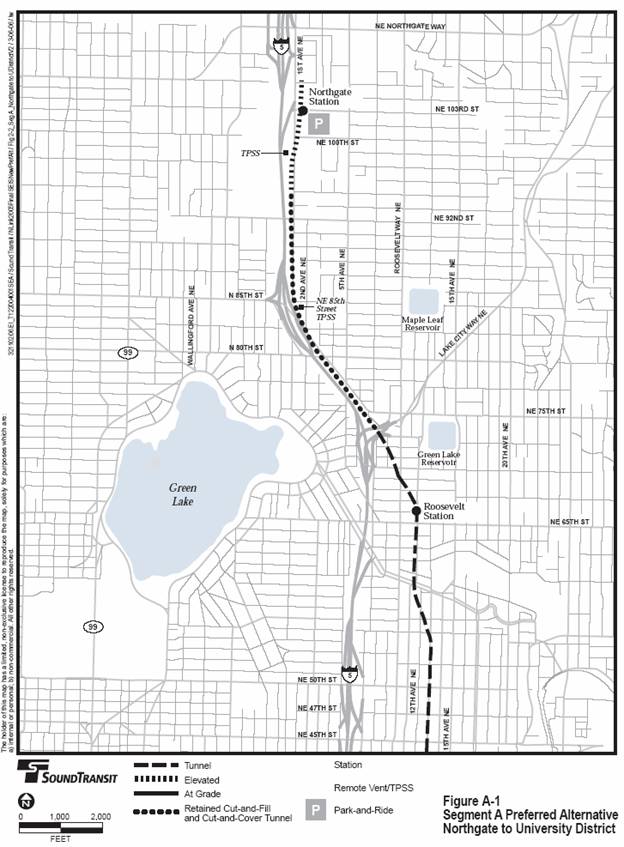
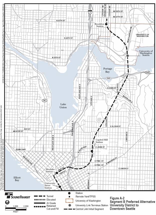
The project to which this North Link ROD applies is more particularly described in Section 2.1 of the North Link Final Supplemental EIS. The project is divided into two geographic segments. Segment A extends from Northgate to the University District, and Segment B extends from the University District to Downtown Seattle.
The project would begin at the end of the Pine Street Stub Tunnel at the north terminus of the Initial Segment and cross under I-5, proceeding in a tunnel east and then north to the Capitol Hill station beneath Nagle Place, south of East John Street. The route would continue via tunnel to a vent facility in the vicinity of East Roanoke Street and 22nd Avenue and then north under the Lake Washington Ship Canal to a station on the University of Washington campus near Husky Stadium. From the University of Washington Station, continuing north in tunnel, the route would reach the Brooklyn Station under Brooklyn Avenue NE south of NE 45th Street. Continuing north in a tunnel, the route would reach the Roosevelt Station just west of 12th Avenue NE between NE 65th Street and NE 67th Street. From the Roosevelt Station, the tunnel route would continue northwest to a portal location immediately north of the Lake City Way interchange with I-5, then continue on the surface, in tunnels, and elevated along the east side of I-5 to the elevated Northgate Station east of First Avenue NE, spanning NE 103rd Street adjacent to the Northgate Transit Center.
The Sound Transit Board selected the University Link project for FTA New Starts funding and as the initial phase for implementation for North Link. University Link would complete the first 3.1 miles of the North Link project from downtown Seattle to the University of Washington with a station at Capitol Hill and an interim terminus station at the University of Washington at Husky Stadium. Funding for future phases has not been secured.
Light rail alternative routes and stations for the North Link Project are described in Chapter 2 and plans of the alternatives provided in Appendix J of the North Link Final Supplemental EIS and Appendix H of the Central Link Final EIS, which are incorporated herein by reference.
Segment alternatives were evaluated, under the project’s stated purpose and need, first to ensure that route and station locations proposed would fit within the whole system and any future expansions and second to compare advantages and disadvantages of route alternatives. These criteria included community compatibility, cost, environmental impacts, political and community acceptance, ridership, and transportation impacts. On May 14, 1998, the Sound Transit Board approved the route and station location alternatives for study in the Central Link Draft EIS. Four route alternatives for Segment A were evaluated, each of which included two stations, and four route alternatives were considered for Segment B, which included four to six stations. After issuance of the Draft EIS and consideration of extensive public and agency comment, the Sound Transit Board identified a preliminary locally preferred alternative (LPA) on February 25, 1999 in Segments B through F. This preliminary LPA was evaluated in the Final EIS.
After the identification of the Initial Segment for Central Link, Sound Transit began evaluating additional alternatives to extend north that would reduce costs and construction risks compared to the original Segment B route selected by the Sound Transit Board in 1999. On February 14, 2002, the Sound Transit Board approved the route and station location alternatives for study in the North Link Draft SEIS and subsequently modified the set of alternatives on May 23, 2002. The Draft Supplemental EIS evaluated three route alternatives, each with two stations, in Segment A and seven route alternatives, with two to four stations, in Segment B. On December 11, 2003, the Board authorized additional study of a Modified Montlake route, which resulted in the Modified Montlake Addendum (February 2004). After issuance of the Draft Supplemental EIS and consideration of extensive public and agency comment, the Sound Transit Board identified a preliminary LPA on May 20, 2004. This preliminary LPA was modified on January 27, 2005 and again on July 28, 2005. The LPA identified on July 28, 2005 was evaluated in the 2005 Draft Supplemental EIS, October 2005, and the Final Supplemental EIS, April 2006.
Attachment B to this ROD provides a summary of the alternatives evaluated for Segments A and B.
The North Link Final Supplemental EIS evaluated the No-build Alternative and different system length alternatives for the proposed light rail line extension.
The No-build Alternative:
The No-build Alternative represents the transportation system and the environment as they would exist without the proposed North Link light rail project. The No-Build Alternative includes the Initial Segment and Airport Link portions of the Central Link light rail system and other regional transit improvements in Sound Move. The 2015 No-Build Alternative refers to the existing transportation system, plus funded projects in the Puget Sound Regional Council’s (PSRC) adopted Transportation Improvement Program, with extension of the Link Initial Segment from S. 154th Street to S. 200th Street in SeaTac. The 2030 No-Build Alternative includes all the transportation projects and programs included in PSRC’s adopted Metropolitan Transportation Plan, Destination 2030.
System Length Alternatives:
Because North Link could be constructed and operated in one phase, moving from south to north, or in two or more phases within the two segments depending on the availability of funding, the potential environmental impacts of the interim termini are evaluated in the Final SEIS as if each station could be constructed and operated as a terminus station. Stations that could serve as an interim terminus for the Preferred Alternative until or unless the system is extended further north are the Roosevelt Station, Brooklyn Station, University of Washington Station, and the Capitol Hill Station. The Sound Transit Board identified “University Link” in the Final SEIS as the preferred initial phase of implementation. This University Link phase would add on to the Initial Segment with the segment from downtown Seattle to the University of Washington with a station at Capitol Hill and an interim terminus station at the University of Washington near Husky Stadium.
Public participation in the development and implementation of Sound Move and Central Link started with the Forward Thrust Plan in the 1960s. This public participation included the use of an advisory panel of civic leaders to provide overall guidance; review and input from subregional groups of elected officials; subarea forums; community and business meetings; and roundtable sessions to gather local input and help develop the plan.
Central Link EIS Scoping Process
From November 1997 to February 1998, Sound Transit distributed a Scoping Information Report to approximately 4,500 households along the proposed corridor, held seven public meetings, and collected over 400 written comments on the environmental analysis and alternatives proposed. In March 1998, comments were described in a Scoping Summary Report.
Between February and June 1998, Sound Transit solicited input from citizens, organizations, and agencies to help define the route alternatives to be included in the Central Link Draft EIS. Sound Transit distributed material describing the route options to approximately 8,000 households along the corridor. To allow community leaders to experience rapid transit systems, Sound Transit sponsored ten field trips to Portland, Oregon and Vancouver, British Columbia, Canada. Eleven community workshops and several walking tours of the proposed routes were sponsored by Sound Transit to engage citizens in exploring the route options and evaluation criteria. The City of SeaTac, Port of Seattle, City of Tukwila, City of Seattle, and King County Metro were involved through special briefing sessions, council presentations, and ongoing coordination meetings. Two formal public hearings served as the final events in the process.
The Draft EIS was circulated to affected local jurisdictions; regional, state, and federal agencies; community organizations; environmental and other interest groups; and interested individuals. The Draft EIS was publicly available on December 4, 1998 and notification of its issuance was published in the Federal Register on December 11, 1998. Over 1,500 Draft EISs were distributed. A 60-day comment period was provided to the public, agencies, and jurisdictions to allow the opportunity to comment on the Draft EIS to Sound Transit and the FTA. Five public hearings were held during the comment period at various locations along the project corridor to take oral testimony. Sound Transit received more than 900 comment letters or public hearing testimonies. These comments, and responses, are included in the Final EIS, Volumes 3, 4, and 5. Other outreach efforts during the EIS process are described in the Final EIS.
North Link Supplemental EIS Process
The North Link Supplemental EIS process began with an agency scoping meeting in October 24, 2001. Public scoping meetings were held on October 24th and 25th, 2001. Between scoping and publication of the Draft Supplemental EIS, Sound Transit participated in approximately 80 community group meetings and briefings throughout the area, including hosting meetings such as two station design workshops and community open houses. With publication of the Draft Supplemental EIS in November 2003, Sound Transit distributed approximately 175 copies to the North Link distribution list. Approximately 90,000 notice of availability postcards were mailed to interested parties in Sound Transit databases and to carrier routes in the project area. Sound Transit held two public hearings on January 7th and 8th, 2004. A 70-day comment period was provided to allow the public, agencies, and jurisdictions the opportunity to comment on the Draft Supplemental EIS to Sound Transit and the FTA. The Modified Montlake Addendum was published in February 2004. A 30-day public comment period was provided, and Sound Transit held a public hearing on February 25, 2004. The 2005 Draft Supplemental EIS was published in October 2005 with a 45-day public comment period. Two public hearings were held on November 9th and 10th, 2005. Sound Transit received approximately 330 comment letters and 63 people spoke at the public hearings on the Draft Supplemental SEIS, the Modified Montlake Addendum, and the 2005 Draft Supplemental SEIS. A summary of the comments and responses can be found in Chapter 7 of the North Link Final Supplemental EIS, and all the comment letters, hearing testimony comments and responses to the comments are included in Appendix N of the Final Supplemental EIS.
Concurrent with the preparation of the North Link Draft Supplemental EIS, Modified Montlake Addendum, 2005 Draft Supplemental EIS, and the Final Supplemental EIS, Sound Transit continued to provide briefings to community groups and host open houses and workshops inviting community involvement in the project. Public notice and involvement efforts are detailed in Appendix B of the North Link Final Supplemental EIS.
BASIS FOR DECISION
PURPOSE AND NEED
The Federal Transit Administration in consultation with Sound Transit (the Central Puget Sound Regional Transit Authority) has determined that the North Link extension as put forth in the Final Supplemental EIS and as described herein meets the purpose and need for the project and the goals established for the project as described and evaluated in each of the Environmental Review Documents. The North Link alternatives would directly serve the densest parts of Seattle and provide reliable service compared to bus transit on increasingly congested roadways. The alternative selected for the extension is preferred because it was determined that it best optimized the goals and objectives of the project. It maximizes ridership by providing a competitive alternative to the automobile for people traveling in the highest-density existing residential and employment areas. It offers reduced costs and construction risk as compared to the original Segment B route. It minimizes potential adverse impacts to the natural and built environment, achieves financial feasibility, and maximizes community support. The segment alternatives selected for the LPA are preferred for the following summarized reasons:
· Segment A. The LPA (12th Avenue NE Tunnel) is in a tunnel through the Roosevelt area, which will have fewer long-term environmental impacts, have construction impacts more focused in a smaller area, and locate the Roosevelt Station more centrally in the Roosevelt business district. The LPA avoids historic and park resources impacted by other alternatives. Public comments also indicate most in the local community support this route.
· Segment B. The LPA (Capitol Hill to University of Washington and University District) is in the high to middle-range of ridership of the alternatives and is considered one of the most cost-effective because it has lower costs and relatively high ridership. The LPA is considered less risky in terms of construction because it crosses the Montlake Cut instead of Portage Bay and does not include a First Hill Station. The Brooklyn Station serves the University District commercial area and urban center. The University of Washington Station and tunnel route across the University campus minimize impacts to the University and directly serves the campus, the University Medical complex and Husky Stadium. The preferred remote vent option minimizes impacts to the Montlake residential neighborhood. The Capitol Hill Station at Nagle Place serves the densely populated Capitol Hill/First Hill urban center. Construction of this station option would avoid a park and have reduced business impacts.
The evaluation of the alternatives is presented in Chapter 6 of the North Link Final Supplemental EIS.
COMMENTS TO NORTH LINK Final Supplemental EIS and Responses
Comments submitted to the PSRC Transportation Policy Board and the Department of Transportation regarding North Link are attached to the ROD in Appendix D as comments on the North Link Final Supplemental EIS. Responses to these comments are also included in Appendix D.
MITIGATION MEASURES TO MINIMIZE HARM
Attachment C, which is incorporated herein by reference, establishes the mitigation measures that are required of Sound Transit under this North Link ROD. The mitigation commitments were identified in the North Link Final Supplemental EIS.
Implementation of the mitigation measures in Attachment C are material conditions of this North Link ROD and will be incorporated in any grant agreement that the FTA may award Sound Transit for the construction of North Link.
The Federal Transit Administration finds that with the accomplishment of these mitigation commitments Sound Transit will have taken all reasonable, prudent and feasible means to avoid or minimize impacts from the preferred alternative.
On a quarterly basis, Sound Transit will submit a Link Environmental Mitigation Program Status Report describing the status of the mitigation-monitoring program to the FTA. Implementation of identified mitigation measures during final design and construction will be the responsibility of Link’s Environmental Manager.
DETERMINATIONS AND FINDINGS
Environmental Findings
The environmental record for the North Link segment of the Central Link Light Rail Project includes the previously referenced North Link Draft Supplemental EIS (November 2003), Modified Montlake Addendum (February 2004), 2005 North Link Draft Supplemental EIS (October 2005) and Final Supplemental EIS (April 2006), as well as the Central Link Draft and Final EIS (December 1998 and November 1999). These documents, all incorporated herein by reference, represent the detailed statements required by NEPA and by 49 U.S.C. Section 5324(b) on:
The environmental impacts of the proposed project;
The adverse environmental effects which cannot be avoided should the proposed project be implemented;
Alternatives to the proposed project; and
Irreversible and irretrievable impacts on the environment which may be involved in the project should it be implemented.
Having carefully considered the environmental record noted above, the mitigation measures as required in Appendix C herein, and the written and oral comments offered by other agencies and the public on this record, the FTA has determined that adequate opportunity was afforded for the presentation of views by all parties with a significant economic, social, or environmental interest, and consideration has been given to the preservation and enhancement of the environment and to the interest of the community in which the project is located; and all reasonable steps have been taken to minimize adverse environmental effects of the proposed project and, where adverse environmental effects remain, there exists no feasible and prudent alternative to avoid or further mitigate such effects.
The ESA of 1973, as amended, provides a means to conserve the ecosystems that threatened and endangered species depend on and a program to conserve such species. The ESA requires federal agencies to ensure that any action authorized, funded or carried out by them is not likely to jeopardize the continued existence of any listed species or result in direct mortality or destruction or adverse modification of critical habitat of listed species. This requirement is fulfilled by consultation and review of the proposed actions and mitigation with the appropriate agency responsible for the conservation of the affected species.
The ESA consultation requirements were implemented for the Central Link and North Link light rail project by the FTA in consultation with the National Oceanic and Atmospheric Administration - National Marine Fisheries Service (NOAA Fisheries) and U.S. Fish and Wildlife Service (USFWS). In December 1999, the FTA submitted a Biological Assessment (BA) to NOAA Fisheries for ESA consultation for the entire Central Link Light Rail Project. NOAA Fisheries indicated that the project’s effects on Chinook salmon (Oncorhynchus tshawytscha), a threatened species, should be evaluated in a Biological Assessment (BA). Also present in the project area is coho salmon (Oncorhynchus kisutch), a candidate species which does not require analysis. However, Sound Transit and the FTA chose to evaluate impacts to coho in case this species becomes listed in the future. NOAA Fisheries identified three species of listed marine mammals potentially occurring in Puget Sound: the endangered humpback whale (Magaptera novaeangliae), leatherback sea turtle (Dermochelys coriacea), and the threatened Stellar sea lion (Eumetopias jubatus). While these three listed marine mammals are not expected to use or occur in the light rail project area, they are discussed in the BA that was prepared for Chinook and coho salmon.
USFWS identified the bald eagle (Haliaeetus leucocephalus) as a listed threatened species, the peregrine falcon (Falco peregrinus) as listed endangered species, and the bull trout (Salvelinus confluentus) as proposed threatened species. Bull trout were subsequently listed as threatened species and peregrine falcons were de-listed. A BA for these three species was prepared and submitted to the USFWS.
During the preparation of the both of the BAs, regular informal consultations occurred between NOAA Fisheries, USFWS, FTA, Sound Transit, and biologists working on the BAs, including briefing sessions, telephone updates, and periodic review drafts. Both of the BA’s were submitted by the FTA to the NOAA Fisheries and to the USFWS on December 2, 1999.
FTA received letters of concurrence for the Central Link project from both the USFWS dated April 24, 2000 and NOAA Fisheries dated May 24, 2000.
A Biological Evaluation (BE) was submitted to NOAA Fisheries on January 3, 2006 requesting NOAA Fisheries concurrence with the determination of “may affect, not likely to adversely affect” critical habitat for PS Chinook salmon for the North Link project. The BE identified proposed design changes to the 1999 BA. FTA stated that the NOAA Fisheries concurrence letter remains accurate for PS Chinook and would remain unchanged and, therefore, that reinitiation is not required for PS Chinook. NOAA Fisheries concurred with the determination that the proposed changes will not alter the prior effect determination for PS Chinook and the FTA finding of “may affect, not likely to adversely affect” critical habitat of PS Chinook in a letter dated February 2, 2006.
On January 3, 2006, FTA forwarded to USFWS a letter and the Biological Evaluation from Sound Transit stating that proposed design changes to the North Link Light Rail Project do not require or warrant reinitiating ESA consultation for peregrine falcon, bald eagle, and bull trout. In addition, reinitiation for Canada lynx (Lynx canadensis), gray wolves (Canis lupus), grizzly bears (Ursus arctos), marbled murrelets (Brachyramphus marmoratus), spotted owls (Strix occidentalis caurina), marsh sandwort (Arenaria paludicola), or golden paintbrush (Castilleja levisecta) is also not warranted due to lack of suitable habitat, lack of presence in project area, lack of potential impacts, and lack of changes in status. Potential impacts to aquatic habitat would likely be reduced by the proposed design changes and would likely not adversely affect bull trout (Salvelinus confluentus) critical habitat. Sound Transit also requested reinitiation of informal consultation for Puget Sound Bull trout critical habitat, because critical habitat for the species was designated after the original 1999 BA and 2000 concurrence letter. In a letter dated May 10, 2006, USFWS concluded that the effects to the Primary Constituent Elements (PCEs) of critical habitat for bull trout that may be found within the proposed action area would be insignificant and concurred with the determination of "may affect, not likely to adversely affect" for bull trout critical habitat.
The project will not adversely affect Essential Fish Habitat (EFH) as designated by the Magnuson-Stevens Fishery Conservation and Management Act (MSA). The proposed project area includes habitat that has been designated as EFH for various life stages of Pacific salmon. NOAA Fisheries determined that the habitat requirements for the MSA-managed species in the project area are similar to that of the ESA-listed species. The conservation measures developed to address ESA concerns are adequate to avoid, minimize, or otherwise offset potential adverse effects to designated EFH. Conservation recommendations pursuant to MSA (§305(b)(4)(a)) are not necessary.
Section 106 of the National Historic Preservation Act of 1966, as amended, requires that federal agencies identify and assess the effects of federally assisted undertakings on historic resources, archaeological sites, and traditional cultural properties, and to consult with interested parties to find acceptable ways to avoid or mitigate adverse effects.
To comply with Section 106 regulations, FTA has consulted with the State Historic Preservation Officer (SHPO) and the Advisory Council on Historic Preservation (ACHP) to determine the project’s adverse effects. Consultations were also conducted with interested parties, including the Suquamish, Muckleshoot, and Duwamish Tribes and the City of Seattle.
No resources eligible for listing on the National Register are adversely affected by the North Link LPA. SHPO concurred with this determination in a letter dated December 7, 2005. In a letter dated April 12, 2006, SHPO stated that they had no additional comments on the North Link Final Supplemental EIS. An Archaeological Resources Treatment and Monitoring Plan will be prepared to stipulate that, if potentially significant archaeological resources are discovered during North Link’s construction, additional work would be required to evaluate their significance and to determine if mitigation measures would be required. Based on the cultural resources analysis and coordination with the Tribes, SHPO, and City, FTA finds that the project will have no effect on any identified or likely cultural or historic resources, and that the Section 106 consultation requirement for this project has been fulfilled.
Section 4(f) of the Department of Transportation (DOT) Act of 1966, 49 U.S.C. 303(c) requires that use of land from a significant publicly owned park, recreation area, wildlife and waterfowl refuge, or historic site, be approved and constructed only if: 1) There is no feasible and prudent alternative to the use of the land; and 2) The project includes all possible planning to minimize harm to the site. A Section 4(f) evaluation must be prepared that describes the affected resources, discusses the direct impacts and the proximity impacts that would substantially impair the use of these resources, and identifies and evaluates alternatives that avoid such impacts and measures to minimize or mitigate for unavoidable adverse effects. FTA included Section 4(f) evaluations in Appendix H of the North Link Final Supplemental EIS. These evaluations have been provided to the Department of the Interior which has found that appropriate consultation with state and local agencies has occurred. The Department of the Interior stated in its letter dated February 15, 2006 that it concurs with the determination that the LPA uses no land protected by Section 4(f) if an entrance or access point for the University of Washington Station is located north of the Burke-Gilman Trail and a grade separated crossing of the Burke Gilman Trail is implemented. As provided in Appendix C: Summary of Mitigation Measures, Sound Transit and FTA are committed to include the entrance or access point north of the trail and a grade separated crossing of the Burke Gilman Trail in the project. The Department of Interior further agreed that other effects of the Preferred Alternative do not result in Section 4(f) use.
With the mitigation commitments, no impacts on Section 4(f) resources are identified for North Link. Based on the previously noted Section 4(f) evaluations, the consultation with the Department of the Interior, and the Section 106 consultation, FTA finds that the North Link project described herein will not use and will not substantially impair any park or recreational resource, any historic site, or any wildlife and waterfowl refuge protected by Section 4(f) of the DOT Act of 1966.
Executive Order 12898, “Federal Actions to Address Environmental Justice in Minority and Low-Income Populations” (February 11, 1994), provides that “each Federal agency shall make achieving environmental justice part of its mission by identifying and addressing, as appropriate, disproportionately high and adverse human health or environmental effects of its programs, policies, and activities on minority and low-income populations.” The Department of Transportation Order (No. 5680.1) to Address Environmental Justice in Minority Populations and Low-Income Populations requires agencies to 1) explicitly consider human health and environmental effects related to transit projects that may have a disproportionately high and adverse effect on minority and low-income populations; and 2) implement procedures to provide “meaningful opportunities for public involvement” by members of these populations during project planning and development. Specifically, the DOT Order states, in part:
8.b. In making determinations regarding disproportionately high and adverse effects on minority and low-income populations, mitigation and enhancements measures that will be taken and all offsetting benefits to the affected minority and low-income populations may be taken into account, as well as the design and comparative impacts and the relevant number of similar existing system elements in non-minority and non-low-income areas.
8.c. The Operating Administrators and other responsible DOT officials will ensure that any of their respective programs, policies or activities that will have a disproportionately high and adverse effect on minority populations or low-income populations will only be carried out if further mitigation measures or alternatives that would avoid or reduce the disproportionately high and adverse effect are not practicable. In determining whether a mitigation measure or an alternative is “practicable,” the social, economic (including costs) and environmental effects of avoiding or mitigating the adverse effects will be taken into account.
As part of the public project planning process through completion of the Central Link Final EIS and the North Link Final Supplemental EIS, Sound Transit and FTA implemented meaningful outreach efforts to minority and low-income communities to assure their active participation. The outreach efforts are described in the Environmental Justice analyses included in these environmental documents.
FTA’s analysis finds that the project would not have disproportionately high and adverse effects on the minority or low-income populations of the Sound Transit District, as provided under the DOT Order on Environmental Justice, particularly in light of the offsetting benefits to minority and low-income populations. The North Link project would provide improved access to transit, reduced travel time, and improved accessibility to employment and services. Appendix I of the North Link Final Supplemental discusses these determinations.
The North Link project is subject to conformity requirements imposed by the Clean Air Act (CAA). The CAA (42 U.S.C. 7506(c)) requires that transportation projects conform to the purposes of the State Implementation Plan (SIP) or Maintenance Plan (SIP/MP). Conformity to a SIP/MP means that the transportation project will not produce new violations of the National Ambient Air Quality Standards (NAAQS) established by the U.S. Environmental Protection Agency, worsen existing violations, or delay timely attainment of the NAAQS.
The EPA conformity regulation (40 CFR part 93) establishes criteria that a transportation project must meet in order to be found by FTA to conform to the SIP/MP. The conformity criteria are that the project be included in a conforming Regional Transportation Plan (RTP) and Transportation Improvement Program (TIP), and that the project not cause or contribute to any localized exceedances of the NAAQS, known as “hot spots.” The North Link project is included in the region’s Metropolitan Transportation Plan, Destination 2030, and in the 2005-2007 Regional Transportation Improvement Plan, both of which have been found by FTA, FHWA, and the Puget Sound Council of Governments to conform, in accordance with the aforementioned EPA regulation.
Further, for carbon monoxide (CO), analyses at specific intersections described in Chapter 4.5 of the North Link Final Supplemental EIS, show that the project would not create a new localized violation of the NAAQS for CO and would not worsen an existing violation. For the project, these intersections represent the “worst case” conditions, and no violations of air quality standards are predicted. FTA therefore finds that the North Link project conforms with the SIP/MP in accordance with the EPA regulations governing such determinations.
Pursuant to Executive Order 11988 Floodplain Management issued May 24, 1977 floodplains were assessed within the 100-year floodplains and floodways defined by the Federal Emergency Management Agency (FEMA) as well as for locations with reported flooding problems or within locally managed floodplains. North Link does not encroach into the floodplains. The North Link LPA does not create new pollution-generating impervious surface (PGIS). New non-pollution generating impervious surface (approximately 267,600 square feet) would be created for the alignment, road improvements, station areas, and vent shafts. Approximately 30,000 square feet of replacement of existing PGIS would occur in providing replacement parking for the University of Washington. Sound Transit will incorporate water quality best management practices as required to meet applicable city, state, and federal stormwater standards and detention will be provided as needed to prevent downstream drainage capacity problems in coordination with the City of Seattle. FTA finds that no adverse impacts to any 100-year floodplains or floodways would occur as a result of the proposed project.
Three major federal laws apply to wetland resources: the National Environmental Policy Act (NEPA), the Clean Water Act, and the Rivers and Harbors Act. NEPA establishes the process for evaluating the environmental impacts of projects such as North Link. This ROD concludes the NEPA process, which included the publication of Central Link Draft and Final EISs, the North Link Draft Supplemental EIS, the Modified Montlake Addendum, the North Link 2005 Draft Supplemental EIS, and the North Link Final Supplemental EIS by FTA. The Clean Water Act, administered by the U.S. Army Corps of Engineers and the U.S. Environmental Protection Agency (EPA), includes two sections applicable to the Link light rail project: Section 404 regulates placement of dredge or fill material into the waters of the U.S. including wetlands. Section 401 ensures that federally permitted projects are consistent with state water quality standards, certification for which is administered by the Washington Department of Ecology. The Rivers and Harbors Act’s Section 10 applies to activities in, over, and affecting navigable waters to preserve the navigability of U.S waters. The Corps of Engineers administers the permit process.
FTA prepared a wetland report for the Central Link light rail project consistent with U.S Army Corps of Engineers guidance for conducting wetland determinations and delineations, as described in the Corps of Engineers Wetlands Delineation Manual, referred to as the 1987 manual (Environmental Laboratory 1987). A Wetland Delineation Report (May 2005) has also been prepared. Segment A would impact approximately 13.5 square feet of class IV wetland, 24.6 square feet of class III wetland, and 170 square feet of wetland buffer as a result of support column placement for elevated track partially within the wetland boundaries. FTA shall require Sound Transit to mitigate impacts to these wetlands in accordance with applicable federal, state, and local regulations. The final mitigation package will be developed during final design and through the appropriate permitting processes in compliance with the requirements of and in coordination with the U.S. Army Corps of Engineers, U.S. EPA, Washington Department of Ecology, and local jurisdictions as may be required. There are no wetland impacts in Segment B, although a Section 404 individual permit and Section 401 Water Quality Certification will likely be required for the tunnel crossing under the Montlake Cut.
Coastal Zone Management (CZM) certification is required for all federally licensed development including Army Corps of Engineers, Section 10 and Section 404 permits, and U.S. Coast Guard Bridge permits. In Washington State, the project proponents prepare the Coast Zone Certification and submit it to the Washington State Department of Ecology (WDOE) to review. WDOE reviews the information based on state environmental and shoreline requirements. Before WDOE issues CZM certification, they require approved water quality certification (which is done by WDOE) and shoreline permits from the local jurisdictions. Consistency with CZM will be demonstrated no later than ninety days before the start of the proposed project construction in the coastal zone. Sound Transit is required to comply with all CZM requirements.
|
The preferred alternative, and other alternatives in the North Link segments (see Figures B-1 and B-2), would serve downtown Seattle, Capitol Hill/First Hill, the University District, Roosevelt, and Northgate. The North Link segment extends from the northern terminus of the Initial Segment at Westlake Station in the Downtown Transit Tunnel north to Northgate. The alternatives for North Link are evaluated in Section 6 of the Central Link Final EIS and the North Link Final Supplemental EIS.
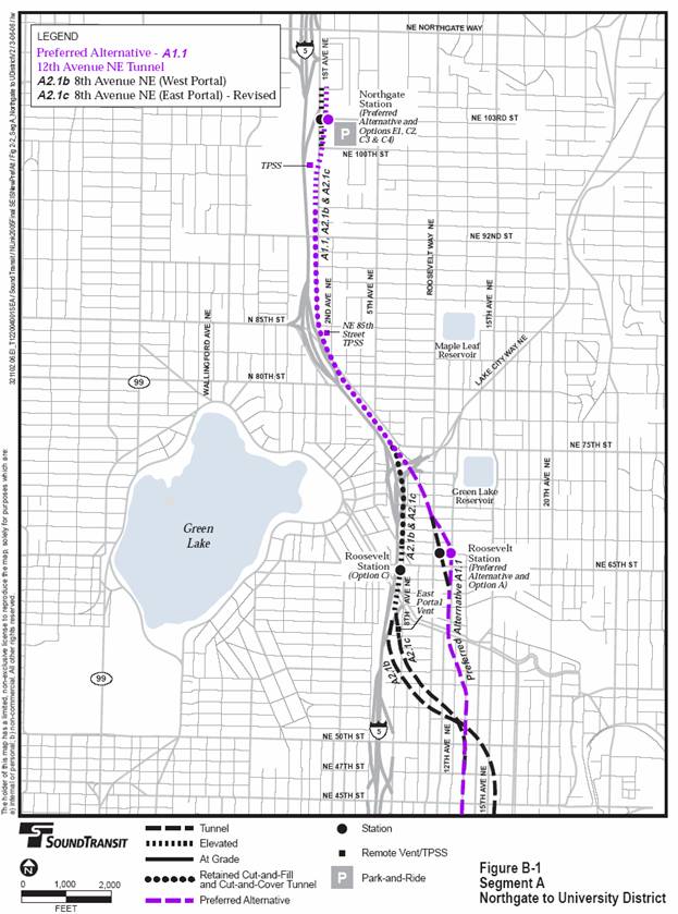
Segment A includes three alternative routes between Northgate and University District, and each includes Northgate and Roosevelt Stations. As shown in Figure 2-2, the Segment A alternatives begin at the south end of Northgate Mall, adjacent to the existing bus transit center, and end just north of NE 45th Street in the University District. Any Segment A route could connect with any of the Segment B routes. The stations are described in more detail following the route descriptions.
The Segment A Preferred Alternative would have elevated, at-grade, and tunnel sections, with two stations:
Northgate (elevated)
Roosevelt (underground)
From the Northgate Station, the route would travel south on an elevated guideway and then in retained cut-and-fill, cut-and-cover and tunnel sections on the east side of I-5, within the freeway right-of-way or slightly east. Near NE 75th Street, the route would enter a tunnel portal and cross under the I-5/Lake City Way off-ramps and continue underground to a Roosevelt Station at 12th Avenue NE north of NE 65th Street. The route would continue south in a tunnel to NE 45th Street to connect to the Segment B Preferred alternatives. (The tunnel route at the south end of this alternative would vary slightly if it connected to other segment routes and stations, but there would be no difference in the above ground facilities of the alternative regardless of the Segment B choice.)
Vent facilities needed for the tunnel section would be provided at the Roosevelt Station. Three traction-powered substations (TPSS) would be required: one at the Roosevelt Station, one located above a cut-and-cover tunnel section adjacent to I-5 near NE 85th Street, and one at the Northgate Station. Three 400-foot tail tracks would be adjacent to 1st Avenue NE, extending north of the Northgate Station in the Northgate Mall parking lot. The tail tracks would be used for short-term light rail vehicle storage and layovers between scheduled runs.
Other route and station options for Alternative A1.1 are also considered, but have not been included as part of the Preferred Alternative. These include route options associated with Northgate Station Options C2 and C3, located at 1st Avenue NE and NE 103rd Street. Northgate Option C4, above 1st Ave NE, has also been developed. Roosevelt Station Option A, an underground station located west of 12th Avenue NE and NE 65th Street, with a diagonal alignment to the streets, also continues to be considered.
Alternative A2.1b includes a different route and profile, different configuration for train storage and layover facilities, and different station options, including:
Northgate (Option E1)
Roosevelt (Option B)
Alternative A2.1b would include a single 400-foot tail track north of the Northgate Station. It would also feature an 800-foot pocket track between NE 90th and NE 95th Streets, adjacent to I-5, for short-term light rail vehicle storage. The route differs from the Preferred Alternative near NE 76th Street, where it would extend under the Lake City Way ramps in a retained cut and continue south on the east side of I-5 in a retained cut and then in a short cut-and-cover segment. The location of the guideway requires shifting 8th Avenue NE to the east between NE 66th and NE 68th Streets. The alignment transitions to an elevated Roosevelt Station just south of NE 65th Street, adjacent to I-5. South of the Roosevelt Station, the route would continue elevated parallel to I-5 and 8th Avenue NE, crossing Ravenna Boulevard with a single 30-foot-wide guideway. Column supports would be placed in the median of Ravenna Boulevard and aligned with the existing piers supporting I-5 nearby. The route would enter a tunnel between the Ravenna Boulevard off-ramp and I-5 (the west portal). This would require relocating the I-5/Ravenna off-ramp slightly to the east. The light rail route would then continue southeast in a tunnel to NE 45th Street in the University District. There are variations in the tunnel route in the south end of this alternative to match with any Segment B route.
The station options considered with this alternative are Northgate Station Option E1, an elevated station at 1st Avenue NE between NE 100th and NE 103rd Streets, and Roosevelt Station Option B, an elevated, side-platform station at 8th Avenue NE and NE 65th Street. As with the Preferred Alternative, a separate structure for a TPSS would be located near NE 85th Street.
Alternative A2.1c features the following station options:
Northgate (Option C2 or C3)
Roosevelt (Option C)
This alternative is similar to Alternative A2.1b, although there have been refinements in the design since the 2003 Draft SEIS. A modified alignment has been developed for the section of the route north of Lake City Way. To preserve areas within WSDOT’s I-5 right-of-way, construction of a cut-and-cover tunnel section has been shifted east, beneath a city street and a corner of Rainbow Point Park, near Banner Way. Alternative A2.1c would have three tail-tracks north of NE 103rd Street. It features Northgate Station options C2 or C3.
The Roosevelt Station Option C is in approximately the same location as the station described in Alternative A2.1b, but involves a center-platform configuration. The section approaching the station, and the station itself, would require reconstructing 8th Avenue NE to the east, from NE 64th to NE 68th Street. This station option requires two separate guideways, each about 15 feet wide and separated by a 10- to 28-foot gap. Column supports would be located within the Ravenna Boulevard median and would align with the existing piers of the nearby 1-5 bridge. The station would also require minor modification to Ravenna Boulevard, west of I-5, to accommodate bus turns to serve the station. To the south of the station, after crossing above Ravenna Boulevard, the route would transition to a tunnel, with an alignment east of A2.1b, to a tunnel portal/ventilation site between NE 58th and NE 60th Streets, east of the I-5 off-ramp. All other system design features are as described in Alternative A2.1b, including the location of a separate TPSS structure near NE 85th Street.
All three route alternatives include a station at Northgate and a station at Roosevelt. While the Northgate Station options could be matched with any of the three alternatives, this Final SEIS combines specific station options with specific route alternatives, as described above, for purposes of analysis. Only the Preferred Alternative (A.1.1) would have a subway station at Roosevelt. Roosevelt Station Options B and C could be paired with A2.1b or A2.1c. The stations are briefly described below, with more detail on station features and facilities such as entrances, pedestrian plazas, bus access and circulation, and bicycle facilities, shown in Appendix J.
The Northgate Station Preferred Alternative is similar to Option C2. The station would be elevated on the east side of 1st Avenue NE, straddling NE 103rd Street south of the Northgate Mall. Pedestrian plazas and station entries would be at the north and south ends of the station. Elevated tracks needed for storage and operations would extend approximately 400 feet north beyond the station into the mall parking area. Park-and-ride spaces displaced by the station would be replaced, either within Metro’s development or in a separate structure for a total of about 410 spaces. The option for developing additional parking would be located south of the station, and would include a garage up to five stories.
The Preferred Alternative for the Roosevelt Station is a revised option developed to avoid a 76-unit residential development that is currently being constructed. This has required realigning the station with 12th Avenue NE, affecting a different set of properties than the previous station design, but remaining within the same area. The Preferred Station would be located between NE 65th and NE 67th Streets and parallel to the west side of 12th Avenue NE. This underground station would have platforms about 80 feet below ground, with entrances on the northwest corner of the NE 65th Street and 12th Avenue NE intersection and near the southwest corner of the NE 67th Street and Roosevelt Way NE intersection. A pedestrian plaza is planned at the southern entrance. The station would be constructed using cut-and-cover methods.
All the Northgate Station options described below are summarized in Table 2-2. All station options are elevated and located south of Northgate Mall, but they differ in station siting, parking facilities, and train storage and turn-back facilities. For all station options, any existing general purpose and park-and-ride spaces displaced by the parking structures would be replaced within the structures. More information on parking is provided in Chapter 3. All stations include bike storage/shelter areas, paratransit, and accessible parking.
Table
B-1
Key Characteristics of Segment A Station Options
|
Station |
Options |
Key Characteristics |
Applicable Alternatives |
|
Northgate |
Preferred Station |
Elevated center platform station on east side of 1st Avenue NE, crossing above NE 103rd Street. Provides replacement for displaced park-and-ride spaces, either in a structure with King County Metro development, or a separate garage (up to 5 stories) south of the station with about 410 spaces. Three tail tracks extend north. |
Preferred Alternative |
|
|
Option C2 |
Elevated station on east side of 1st Avenue NE straddling 103rd Street. The 6-story and 4-story parking structures provide replacement for displaced parking for a total of 1,400 parking spaces in the structure. Three 400-foot tail tracks to the north. |
A1.1, A2.1c |
|
|
Option C3 |
Same as Option C2 except parking structures are different. The 3-and-a-half story structure and 6-story structure provide a total of 1,300 parking spaces for displaced parking spaces. |
A1.1, A2.1c |
|
|
Option C4 |
An elevated center platform station above 1st Avenue NE, and crossing above NE 103rd Street. Same replacement parking option as Preferred Alternative. |
A1.1 |
|
|
Option E1 |
Elevated station on east side of 1st Avenue NE between NE 100th Street and NE 103rd Street. A 5-story parking structure with 1,000 spaces provides replacement for displaced parking. A single 400-foot trail track to the north. |
A2.1b |
|
Roosevelt |
Preferred Alternative |
A cut-and-cover tunnel station located at 12th Avenue NE and NE 65th Street . Features a center platform, and entrances at NE 65th and NE 67th Streets, on 12th Avenue NE. |
Preferred Alternative |
|
|
Option A |
Cut-and-cover tunnel station located at 12th Avenue NE and NE 65th Street, crossing diagonally to Roosevelt Way NE. |
A1.1 |
|
|
Option B |
Elevated station with side platforms located at 8th Avenue NE and NE 65th Street |
A2.1b, A2.1c (refined) |
|
|
Option C |
Elevated station with center platform located at 8th Avenue NE and NE 65th Street. |
A2.1c |
Option C2 would have the same location and configuration as the Preferred Alternative, but the associated parking facilities differ. Two parking structures would be included for a total of approximately 1,400 spaces. A six-story structure with about 560 park-and-ride spaces would be located north of NE 100th Street, west of the existing transit facility and south of the light rail station. Entrances to this parking structure would be from NE 100th Street and 1st Avenue NE. The second parking structure would be between NE 103rd Street and the Northgate Mall. This structure would be four stories with 400 general purpose spaces and 450 park-and-ride spaces.
Option C3 is similar to station Option C2 but with different configurations and sizes for the three parking structures, with a total of about 1,300 parking spaces. Two three-and-a-half-story parking structures would be located north of the light rail station on the east side of 1st Avenue NE, and the structures would span the existing mall entrance. To replace displaced parking, the structures would provide 300 general purpose spaces and 445 park-and-ride spaces for a total of 745 spaces. The six-story second parking structure would be located north of NE 100th Street and southeast of the station, with 560 park-and-ride spaces for displaced surface park-and-ride spaces. An entrance roadway would provide access to the structures and adjacent mall parking lots.
Option E1 would be located on the east side of 1st Avenue NE between NE 100th and NE 103rd Streets. A five-story parking structure with approximately 1,000 park-and-ride spaces would be located between the station and the existing transit facility, providing replacement for displaced spaces. Access to the parking structure would be from NE 100th and NE 103rd Streets.
Option C4 (1st Avenue Option) would be located between NE 100th and NE 103rd Streets and straddle 1st Avenue NE. This elevated station would have entrances at the north and south ends of the station. The station would have a center platform with northbound and southbound tracks on the sides, and a tail track extending to the north. The facility retains travel lanes on 1st Avenue NE and would have a 400 foot long tail track extending north of the station and NE 103rd Street. The station platform and the light rail guideways would be located directly over 1st Avenue NE to reduce the areas needed within Northgate Transit Center property owned by King County Metro, as well as private Northgate Mall property. This option would have the same impacts and replacement as the Preferred Alternative.
Option A would generally be similar to the Preferred Alternative, Option A1, described above, however this option would be sited diagonally between NE 65th and NE 67th Streets. Station entrance would be on the north side of NE 65th Street, near 12th Avenue NE, and at the southeast corner of Roosevelt Way and NE 67th Street. The station includes elevators, escalators, bike storage, and paratransit stops.
Options B and C are elevated options located on the west side of 8th Avenue NE between NE 65th Street and NE Ravenna Boulevard. Option B would have side platforms, which have northbound and southbound tracks in the middle and platforms on the sides. Option C features a center platform with tracks on each side. Alternative A2.1b features Option B, and A2.1c features Option C; as noted above, this also affects the configuration of the elevated facilities to and from the station, but all other characteristics of Options B and C are similar. Station Options B and C could be paired with either Alternative A2.1b or A2.1c.
As shown in Figure 2-4, there are eight Segment B route alternatives connecting the University District to downtown Seattle, and all are entirely tunnel routes. Any of the Segment B alternative routes could connect with any of the Segment A alternative routes, and all end with a connection to the Initial Segment in the DSTT. The details of the eight route alternatives overlap considerably, with some alternatives differing only at the north or south ends of the segment or in the station locations and related facilities. The station options for each alternative are listed below and described in more detail in Section 2.3.7.
The Segment B Preferred Alternative would serve the University District and Capitol Hill, and it would include the following three stations:
Brooklyn (Option B – Refined)
University of Washington
Capitol Hill
From the North, the Preferred Alternative would have a station serving the northern University District area with a station at Brooklyn, and extend southeast under the campus to a University of Washington Station at the Montlake Triangle and Husky Stadium. The Preferred Alternative then crosses under the Lake Washington Ship Canal approximately 200 to 300 feet east of the Montlake Bridge and travels southwest and south under 10th Avenue E to the Capitol Hill Station. The route then makes its way westward to a connection with the Initial Segment under Pine Street, east of the DSTT.
Vent facilities would be provided in the vicinity of stations and in a separate structure located at the southwest corner of SR 520/Montlake Interchange, north of E Roanoke Street. The 2003 Draft SEIS identified a previous option (Option C) to house a vent facility and TPSS at this site. However, further design has relocated the TPSS and communication room to the University of Washington Station, and the Preferred vent facility is smaller than Option C.
This alternative is similar to the original project route selected by Sound Transit in 1999 and examined in the FEIS. It would serve the University District area, Capitol Hill, and First Hill. This alternative includes the following four stations:
NE 45th (Option A)
Pacific
Capitol Hill (either Broadway or Nagle options)
First Hill
The route would begin at the NE 45th Station at 15th Avenue NE and extend south under 15th Avenue NE to the Pacific Station. From the Pacific Station, the route would extend beneath Portage Bay and continue under the Portage Bay/Roanoke neighborhoods to 10th Avenue E Depending on which Capitol Hill Station is used, between E Galer and E Republican Streets the route would shift to Broadway (if the Broadway Station is selected) or remain under 10th Avenue E (if the Nagle Station is selected). From the Capitol Hill Station the route would continue southwest to reach the First Hill Station. From the First Hill Station the route would connect to the Initial Segment under Pine Street east of the DSTT.
Vents would be provided in the vicinity of all stations and in a structure south of State Route (SR) 520 between 10th Avenue E and Federal Avenue E TPSSs would be placed within the Pacific Station, within the vent structure south of SR 520, and within the Capitol Hill Station or its adjacent crossover tracks.
This alternative would serve the University District, Montlake, Capitol Hill, and First Hill, with the following four stations:
Brooklyn (Option C) or NE 45th (Option B)
Montlake
Capitol Hill (either Broadway or Nagle options)
First Hill
The route would generally begin at NE 45th Street at either a Brooklyn Station or a NE 45th Station and extend southeast under the University of Washington campus to a Montlake Station. Slightly different routes are required to reach the Montlake Station depending on whether a Brooklyn Station or NE 45th Station is used. From the Montlake Station, the route would extend beneath the Lake Washington Canal about 200 to 300 feet east of the Montlake Bridge and continue southwest under the Montlake and Capitol Hill neighborhoods to a station at Capitol Hill (either the Broadway or Nagle options). South of the Capitol Hill Station the route would be the same as described for Alternative B1.A.
Vent facilities would be provided in the vicinity of stations and in a separate structure with two options in the vicinity of 19th Avenue E between E Lynn and E Boyer Streets, and one option south of the SR 520/ Montlake Boulevard interchange. TPSSs would be needed at the Montlake Station, within the Montlake area vent shaft structure, and within the Capitol Hill Station or crossover.
This alternative would serve the University District, Capitol Hill, and First Hill and would have three to four stations, listed below:
Brooklyn (Options A, B, or C)
Southwest Campus (optional station paired with Brooklyn Options A or B)
Capitol Hill (either Broadway or Nagle options)
First Hill
The route would begin near NE 45th Street at the Brooklyn Station. There are two West Tunnel Station Options. B1.Ga does not include a Southwest Campus Station and B1.Gb does. If the Southwest Campus Station is not included (B1.Ga), the route would extend under Brooklyn Avenue NE to about NE 42nd Street, and then southwest to cross under Portage Bay 200 to 300 feet east of the University Bridge, continuing to 10th Avenue E north of SR 520. With the option for a Southwest Campus Station (B1.Gb), the route would be under Brooklyn Avenue NE. From the Southwest Campus Station, the route would extend under Portage Bay about 700 feet east of the University Bridge and continue to 10th Avenue E north of SR 520. The remainder of the route would be the same as described for Alternative B1.A (First Hill to 15th Avenue NE).
Vent facilities would be provided in the vicinity of stations and in a structure just south of SR 520 between 10th Avenue E and Federal Avenue E TPSSs would be needed within the Southwest Campus Station (for a route with four stations). If the Southwest Campus Station was not constructed under this alternative, the TPSS would be located within the Brooklyn Station. TPSSs would also be needed within the vent structure just south of SR 520, and also within the Capitol Hill Station or crossover.
This alternative would connect the University District, Montlake, Eastlake, and downtown Seattle via the South Lake Union area to the west of I-5. This alternative includes the following three to four stations:
Brooklyn (Option C or NE 45th Option B)
Montlake
Harrison
Convention Place (optional station)
The route and stations from a NE 45th or Brooklyn Station to the Montlake Station would be the same as Alternative B1.D (First Hill to Montlake). From the Montlake Station, the route would extend south beneath the Lake Washington Ship Canal about 200 to 300 feet east of Montlake Bridge and continue southwest under the Montlake and Capitol Hill neighborhoods to pass under I-5 at Republican and Mercer Streets. The route would extend under Eastlake Avenue E to the Harrison Station. From the Harrison Station, the route would continue under Eastlake Avenue E and Howell Street, with an option to connect to a new Convention Place Station for light rail beneath a rebuilt Convention Place Station bus station. The route would then connect with the Initial Segment of Link in the DSTT.
Vent facilities would be provided in station areas with two options located near 19th Avenue E between E Boyer Avenue and E Lynn Street and one option by Montlake Boulevard/SR 520. TPSSs would be needed within the Montlake Station, within the Montlake area vent shaft structure, and within the Harrison Station.
This alternative would connect the University District to downtown Seattle via the South Lake Union area to the west of I-5. This alternative would have the following two to four stations:
Brooklyn (Options A, B, or C)
Southwest Campus (optional station paired with Brooklyn Option A or B)
Harrison
Convention Place (optional station)
In the north section, from the Brooklyn Station to the SR 520 vent shaft, the alternative is similar to Alternative B1.G (First Hill to West Tunnel) both with and without a Southwest Campus station. After crossing under SR 520, the route would turn to the southwest at about E Highland Drive and would pass under I-5. From there the route would be the same as described for Alternative B3.D (Eastlake to Montlake), with a route under Eastlake Avenue E to the Harrison Station and then to Howell Street to either an optional Convention Place light rail station or a direct connection to the Initial Segment.
Vent facilities would be provided in the vicinity of stations, and just south of SR 520, between 10th Avenue E and Federal Avenue E. TPSSs would be needed within the Southwest Campus Station (for a four-station route). If the Southwest Campus Station was not constructed under this alternative, the TPSS would be located within the Brooklyn Station. TPSSs would also be needed within the vent shaft structure just south of SR 520 and within the Harrison Station.
This alternative would connect the University District, Montlake, Capitol Hill, and downtown Seattle. This alternative includes the following three stations:
Brooklyn (Option C) or NE 45th (Option B)
Montlake
Capitol Hill (either Broadway or Nagle options)
This alternative would have much the same route and station options as Alternative B1.D (First Hill to Montlake), except that it does not include a First Hill Station and the related First Hill route section. Due to the shorter route length, the alternative also does not require crossover tracks at the Capitol Hill Station options at Broadway or Nagle. From the Capitol Hill Station, the route would extend south and then west to pass under I-5 at Boren Avenue to connect to the Initial Segment in the Downtown Seattle Transit Tunnel. All other physical features of this alternative are the same as Alternative B1.D (First Hill to Montlake).
This alternative would connect the University District, Capitol Hill, and downtown Seattle and would have the following two to three stations:
Brooklyn (Options A or C)
SW Campus
Capitol Hill (either Broadway or Nagle options)
The route is similar to Alternative B1.G (First Hill to West Tunnel) except that it does not include a First Hill Station and the related First Hill route section. This route also includes the West Tunnel options, either with the Southwest Campus Station (B1.Gb) or without (B1.Ga). From the Capitol Hill Station, the route would extend south and then west to pass under I-5 at Boren Avenue to connect to the Initial Segment under Pine Street in the Downtown Seattle Transit Tunnel. All other features are the same as Alternative B1.G.
All Segment B stations are underground. However, the depth of the station and its location in the corridor are factors in the construction technique anticipated, which would be either mining or cut-and-cover excavation. Table 2-3 briefly summarizes the options, construction techniques anticipated, and applicable alternatives.
Table B-2
Key Characteristics of Segment B Station Options
|
Station |
Options |
Key Characteristics |
Applicable Alternatives |
|
NE 45th |
Option A |
Deep mined station at NE 45th and 15th Avenue NE |
B1.A (First Hill to 15th Avenue NE) |
|
|
Option B |
Cut-and-cover station at NE 45th and 15th Avenue NE |
Montlake routes: B1.D, B3.D, B4.D |
|
Brooklyn |
Option A |
Cut-and-cover station north of NE 45th at Brooklyn Avenue NE |
West tunnel routes with or without Southwest Campus station: B1.Gb, B3.Gb, B4.Gb |
|
|
Preferred Alternative |
Cut-and-cover station south of NE 45th at Brooklyn Avenue NE |
Preferred Alternative |
|
|
Option B |
Cut-and-cover station south of NE 45th at Brooklyn Avenue NE |
B1.G, B3.G |
|
|
Option C |
Cut-and-cover station north of NE 45th at Brooklyn Avenue NE |
West tunnel routes without Southwest Campus station: B1.Ga, B3.Ga, B4.Ga |
|
|
Option D |
Cut-and-cover station south of NE 45th Street at Brooklyn Avenue NE. |
Variation of Preferred Alternative |
|
Montlake/Rainier Vista |
none |
Cut-and-cover station northwest of Montlake and Pacific intersection |
Montlake routes: B1.D, B3.D, B4.D |
|
University of Washington |
Preferred Alternative |
Cut-and-cover station at southwest corner of Husky Stadium |
Preferred Alternative |
|
Southwest Campus |
Optional station |
Cut-and-cover station at Brooklyn Avenue NE/NE 40th Street |
West tunnel routes with Southwest Campus station: B1.Gb, B3.Gb, B4.Gb |
|
Pacific |
none |
Mined station at Pacific Street and 15th Avenue NE |
B1.A (First Hill to 15th Avenue NE) |
|
Harrison |
none |
Cut-and-cover station at Eastlake Avenue and Harrison Street and a pedestrian bridge over I-5 |
Eastlake routes: B3.D, B3.G |
|
Capitol Hill |
Preferred Alternative |
Cut-and-cover station between Broadway and Nagle Avenues, and south of John Street |
Preferred Alternative |
|
|
Broadway |
Cut-and-cover station near Denny Street and under Broadway |
First
Hill routes: B1.A, B1.D, B1.G |
|
|
Nagle |
Cut-and-cover station near Denny Street and under Nagle |
First Hill routes: B1.A, B1.D, B1.G Capitol Hill routes: B4.D, B4.G |
|
First Hill |
none |
Mined station at E Madison Street/Boylston Avenue |
First Hill routes: B1.A, B1.D, B1.G |
|
Convention Place |
none |
Cut-and-cover rail station with rebuilt bus station above |
Eastlake routes: B3.D, B3.G |
Depending on the length of the route and the number of stations, some stations include traction power and crossover facilities, which are often placed adjacent to stations to reduce construction costs. As noted in the discussion of alternatives, all of the stations feature vent facilities, which may be located at station entrances or emergency exit stairs or within the crossover facility. All of the stations feature bicycle storage and other passenger amenities. Figure 2-3 provides typical views of tunnel stations and provides a general perspective of the scale of features—such as vents —that are incorporated within the station design. Conceptual design drawings in Appendix J of the FSEIS illustrate the station setting and the location of entrances, vents, TPSSs, elevators, stairs, and other facilities and also indicate the preliminary bus circulation and locations of bus zones near the stations. Deep-mined stations have high-speed elevator access only (and emergency stairs).
The Brooklyn Station for the Preferred Alternative is station Option B evaluated in the 2003 Draft SEIS. The underground station would be located south of NE 45th Street at Brooklyn Avenue NE, with entrances on NE 45th Street and NE 43rd Street. The north entrance is on NE 45th Street, west of Brooklyn Avenue NE, within a plaza area north of the Safeco tower. The south entrance is north of NE 43rd Street, east of Brooklyn Avenue NE. There would be elevators, escalators, and stairs from the entrances to the platform, which would be about 80 feet below ground. The above-ground station facilities would include ventilation and emergency stairs. Bike storage would be provided, primarily at the NE 43rd Street entrance.
The underground University of Washington Station would be located at the southwest corner of Husky Stadium, east of Montlake Boulevard and Pacific Street. The station is similar to Option B evaluated in the Modified Montlake Route Addendum. One entrance would be by the stadium east of Montlake Boulevard. A second entrance would be west of Montlake Boulevard, near NE Pacific Place, with a pedestrian walkway tunnel under Montlake Boulevard. There is an option for an extended tunnel or overhead walkway to an optional entrance north of NE Pacific Place and the Burke-Gilman Trail. Grade separated pedestrian access across Montlake Boulevard and NE Pacific Place could also be accommodated with an elevated overpass instead of tunnels. There would be elevators, escalators, and stairs from the entrances to the station platform, which would be about 110 feet below ground. The above-ground station facilities would include ventilation and emergency stairs. Bike storage would be provided, including a covered bike storage area (or “barn”) for about 134 bikes. Crossover tracks would be built to the south of the station platform, and a third storage track would be included west of the platform. The station would be constructed using cut-and-cover techniques, excavating from the surface, requiring use of Stadium area parking lots.
The underground Capitol Hill Station is located between Broadway and Nagle Avenues, south of John Street, with two entrances on the east side of Broadway, and a potential third entrance on the west side of Broadway. Elevators and escalators would carry passengers from the entrances to the station platform 90 feet below ground. In addition to housing the entrances, the above-ground station buildings would also include ventilation and emergency stairs. There would be bike shelter areas for bike storage, with the main area at the Denny Street entrance. The station would be constructed using cut-and-cover techniques, excavating from the surface.
The NE 45th Station has two options (A and B), both located underground between 15th Avenue NE and the Burke Museum. For either option, the station would extend from a north entrance in the southeast corner of the intersection of NE 45th Street and 15th Avenue NE to a south entrance on the east side of 15th Avenue NE at NE 43rd Street. Bicycle storage would be primarily at the north entrance. Option A would be deep mined 180 to 200 feet deep and Option B would be constructed with cut and cover methods and is 90 to 110 feet below ground.
Option A and Option C for Brooklyn Station would feature a north entrance at the southwest corner of the intersection of NE 47th Street and Brooklyn Avenue NE and a south entrance at the northeast corner of NE 45th Street and Brooklyn Avenue NE. Option A would be about 115 feet below ground, and Option C would be about 110 feet below ground. Bike storage for Options A and C would be primarily at the NE 47th Street entrance. Option B would be similar to the Preferred Alternative, and would be about 120 feet below ground, with entrances on the southwest corner of NE 45th Street and NE Brooklyn Avenue NE, and on the northeast corner of NE 43rd Street and Brooklyn Avenue NE. Option D, which would be about 80 feet below ground, would be similar to the Preferred Alternative and would extend from a north entrance at the southwest corner of the intersection of NE 45th Street and Brooklyn Avenue NE to a south entrance in the southwest corner of NE 43rd Street and Brooklyn Avenue NE.
The Montlake Station would be located 40 to 60 feet beneath Rainier Vista on the University of Washington campus, north of NE Pacific Place and the Triangle Parking Garage. A north entrance would be on the south side of Stevens Way and a south entrance would be located between NE Pacific Place and the Burke-Gilman Trail. An alternate location for the north station entrance would be on the east side of Rainier Vista south of Stevens Way. An alternative location for the south entrance would be west of Rainier Vista between Pacific Place and the Burke-Gilman Trail. Bicycle storage would be located close to the south station entrance near the Burke-Gilman Trail.
The Southwest Campus Station would be located 50 to 60 feet beneath Brooklyn Avenue NE at NE 40th Street with a south entrance on the east side of Brooklyn Avenue NE between NE Pacific Street and the Burke-Gilman Trail. The north entrance would be located at 40th Street NE and Brooklyn Avenue NE. Bicycle storage would be located near the south station entrance. This station is optional for the West Tunnel routes.
The Pacific Station would be located 90 to 110 feet beneath NE Pacific Street and the south portion of the block north of NE Pacific Street between University Way NE and 15th Avenue NE. A north entrance would be on the west side of 15th Avenue NE about midway between NE 40th and NE Pacific Streets, and a south entrance would be at the intersection of NE Pacific Street and 15th Avenue NE. Bicycle storage facilities would primarily be in the northeast corner of the intersection of NE Pacific Street and University Way NE.
The Broadway Option for the Capitol Hill Station would be located about 120 feet beneath Broadway with a north entrance at the southwest corner of the intersection of E John Street and Broadway, and a south entrance on the west side of Broadway between E Denny Way and E Howell Street.
The Nagle Option for the Capitol Hill Station would be about 90 feet under Nagle Place, at E Denny Way between Broadway and 10th Avenue E. A north entrance would be at the southeast corner of the intersection of E John Street and Broadway, and a south entrance would be on the east side of Broadway between E Denny Way and E Howell Street. An optional second south station entrance would be located at the northwest corner of the intersection of E Howell Street and Broadway. When paired with longer route alternatives, such as the First Hill route, crossover tracks are required south of the station.
The Harrison Station would be located 50 feet beneath Eastlake Avenue E with a north entrance at the southwest corner of Republican Street and Eastlake Avenue E and a south entrance in the southwest corner of Harrison Street and Eastlake Avenue E Bicycle storage would be provided near both entrances.
The station would also include a pedestrian bridge extending over I-5 to provide pedestrian access to the station for areas east of I-5. The west end of the bridge would be a 100-foot to 150-foot tower containing stairs and high-speed elevators. The tower would be located over the north station entrance at Republican and Eastlake. The lower bridge option would extend east 360 feet from the tower across I-5 to the west side of Melrose Avenue E, and the higher bridge option would extend 520 feet to the alley between Bellevue and Melrose avenues. Although the design for the bridge remains conceptual, potential bridge types include cable-stayed and arch. With the lower bridge option, a funicular, or hill-side cable railway, would connect the bridge to an entry plaza located on the west side of the alley between Bellevue and Melrose avenues.
The First Hill Station would be over 200 feet underground along the north side of E Madison Street, between Boylston and Summit Avenues, with two entrances from Madison. In addition to the entrances, the above ground building would incorporate ventilation, equipment rooms, and emergency stairs that were previously underground in the 2003 Draft SEIS design. Four high-speed elevators at each entrance would carry passengers from the surface to a station platform approximately 215 feet below ground. Bike storage would be provided at both entrances. The station would be constructed using mining techniques, with two shafts mined from the surface to reach the tunnels and the station below.
A new rail-only Convention Place Station would be built beneath the existing Convention Place DSTT bus-only station, requiring complete reconstruction of the existing bus station. The platforms would be 40 to 60 feet below ground. The station’s north entrance would be at the south corner of the intersection of Howell Street and Boren Avenue with a south entrance at the north corner of the intersection of 9th Avenue and Pine Street adjacent to the existing entrance to the bus tunnel. The north station entrance at Howell and Boren would include bicycle facilities. The Convention Place Station is optional, and is available only for alternatives with an Eastlake route. If a light rail station is not provided for an Eastlake route, the existing bus station would still need to be reconstructed.
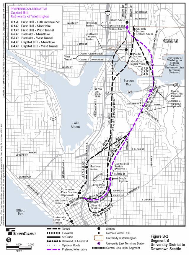
June 2006
This attachment lists the mitigation commitments made by the Federal Transit Administration (FTA) and Sound Transit for the North Link Segment[1] of the planned Central Link Light Rail Project. In addition to outlining the specific mitigation measures required under this Record of Decision (ROD), this list is provided here to facilitate the monitoring of the implementation of the mitigation measures and to give a sense of the nature of the mitigation actions and associated impacts.
The mitigation commitments identified for the North Link project in this ROD shall and must be implemented by Sound Transit if the project, as described in the ROD, proceeds with FTA financial assistance. These mitigation measures are now incorporated into the definition of the project, and Sound Transit shall implement them, provide funding for their implementation, or ensure that other agencies fund and implement them (although this would not alleviate Sound Transit’s overall responsibility for implementation). Sound Transit is prohibited from withdrawing or substantially changing any of the mitigation commitments identified in the ROD for the project without express written approval by FTA. In addition, any change to the project that may involve new or changed environmental or community impacts not yet considered in the existing environmental record must be reviewed in accordance with FTA environmental procedures (23 CFR Part 771) and approved by FTA.
Mitigation measures associated with the operation of the project are described first in Section 1 of this Attachment. Mitigation measures associated with the construction of the project are described in Section 2. North Link consists of two segments: Segment A is from Northgate to the University District and Segment B is from the University District to Downtown Seattle. Mitigation for impacts by subject area is discussed separately by segment. Mitigation associated with a particular station, facility, or section in a segment will only be implemented with construction or operation of that particular component.
Sound Transit will establish a mitigation monitoring program during final design, construction, and start-up. The purpose of the mitigation monitoring program is 1) to assist Sound Transit in fulfilling its commitments set forth in the environmental documents, and 2) to give FTA a means of checking that its mitigation requirements are, in fact, being met. The monitoring program will consist of three activities:
· The maintenance and updating of the list or database of mitigation commitments by Sound Transit.
· Tracking the status of implementation of the mitigation measures by Sound Transit.
· Quarterly review by Sound Transit and FTA.
No adverse impacts have been identified and no mitigation is proposed.
No adverse impacts have been identified and no mitigation is proposed.
No adverse impacts have been identified and no mitigation is proposed.
No adverse impacts have been identified and no mitigation is proposed.
No adverse impacts have been identified and no mitigation is proposed.
Hide-and-ride impacts may occur in station areas;
· Sound Transit will work with the City of Seattle to pursue appropriate on-street parking measures to discourage hide-and-ride activity in station areas. To identify appropriate parking controls, Sound Transit will conduct on-street parking inventory surveys around each station up to one year prior to station opening to document existing on-street parking supply within a 1/4-mile radius of the station areas. Based on survey results, Sound Transit and City staff will work with affected stakeholders to identify and implement appropriate mitigation elements prior to station opening.
· Mitigation measures may include paid parking meters, time-limit signs, passenger drop-off/pick-up zones, truck and load/unload zones, and residential parking zones (RPZs) within a 1/4-mile radius of each station. For locations where the mitigation is accepted and approved by City staff and local community or neighborhood groups, Sound Transit would provide funding for implementing appropriate parking controls (e.g., meters or pay stations and signs), labor, and all other related installation costs.
· City staff will monitor all parking controls during the first 2 two years after the system opens and determine if RPZ boundaries or other on-street controls are insufficient. Sound Transit will fund any expansions of existing or newly-created RPZs or other parking controls during the first two years following station opening, when the expansion can be attributed to light rail hide-and-ride parking impacts. The City of Seattle will be responsible for the installation of any additional parking controls deemed necessary after this time. Parking enforcement in the North Link station areas will be provided by the City of Seattle Police Department.
· Sound Transit will compensate affected property owners or replace displaced off-street parking according to provisions specified in Sound Transit’s Real Estate Property Acquisition and Relocation Policy, Procedures, and Guidelines.
The NE Northgate Way/5th Avenue NE intersection would operate at LOS F under both of the No-Build and Build Alternatives in the year 2030.
· Sound Transit will contribute a fair share of costs to improve this intersection, based on the proportionate share of PM peak hour project trips to total trips traveling through the intersection.
· Signs will be placed at Northgate Mall to restrict use of mall parking by light rail patrons.
· Sound Transit will provide one-to-one replacement of displaced off-street park-and-ride spaces at the Northgate transit center.
As part of the project, Sound Transit will provide sidewalks on station property immediately adjacent to stations. The stations also include facilities for bicycle access, circulation and storage.
· For the Northgate Station, the improvements include sidewalks on the east side of 1st Avenue NE between NE 100th and NE 103rd Streets and on the north side of NE 100th Street and south side of NE 103rd Street between 1st Avenue NE and the transit center.
· For the Roosevelt Station, Sound Transit will work with the City of Seattle, Seattle Public Schools, and the neighborhood to determine the most appropriate treatments to provide for safe and effective pedestrian access at 12th Avenue NE and NE 67th Street; options could include painted crosswalks or signals, street lighting, warning lights or signage.
· The NE Pacific Place/Montlake Boulevard NE intersection would operate at LOS F in the years 2015 and 2030. Adding a second westbound left-turn lane would improve operations to better than No-Build conditions, which would be at LOS F by 2030 and LOS E in 2015. Sound Transit will contribute a proportionate share of costs to improve this intersection.
· At the Broadway E/E Olive Way/E John Street intersection, the high pedestrian volumes occurring at this intersection often block vehicles making left turns, resulting in long vehicle queues. Sound Transit will work with the City of Seattle to determine and implement appropriate traffic control measures, such as prohibiting eastbound and westbound left turns at this intersection during the PM peak hour period to reduce or eliminate queues.
At the University of Washington Station, Sound Transit will continue to work with local agencies (KCM, WSDOT, SDOT, and the University of Washington) to identify University of Washington Station design features to accommodate the increase in pedestrians associated with North Link. Design improvements such as reduced speed limit signs for bicycles, distinctive paving, or other improvements to enhance visibility and slow bicycle travel speeds along the Burke-Gilman trail in this area will be implemented as necessary to reduce the likelihood of bicycle/pedestrian collisions. An unsignalized or signalized midblock crossing of NE Pacific Place will be provided to help balance transportation needs. A station entrance or access point will be located to the north of NE Pacific Place and the Burke-Gilman Trail with an extended pedestrian passageway under or over NE Pacific Place and the Burke-Gilman Trail.
In the vicinity of the south station entrance, Sound Transit will provide sufficient facilities for pedestrian storage and capacity by improving and widening the crosswalks across Montlake Boulevard NE and NE Pacific Street, and providing sufficient pedestrian storage capacity on either the existing refuge/traffic island or south end of the Montlake Triangle.
· For permanent parking loss at the University of Washington Station, Sound Transit will provide replacement parking or compensation for the parking loss.
Sound Transit will compensate and assist affected property owners according to the provisions specified in Sound Transit’s adopted Real Estate Property Acquisition and Relocation Policy, Procedures, and Guidelines. Sound Transit will comply with appropriate provisions of the federal Uniform Relocation Assistance and Real Property Acquisition Policies Act of 1970 and Uniform Relocation Act Amendments of 1987 and the State of Washington’s relocation and property acquisition regulations (Washington Administrative Code [WAC] 468-100). Benefits will vary depending on the level of impact, available relocation options, and other factors.
Sound Transit will contact property owners whose property would be directly affected to answer questions and provide additional information about relocation assistance services, payments, and reimbursement eligibility. Sound Transit’s relocation assistance advisory services will include, but not be limited to, measures, facilities, or services that may be necessary or appropriate to determine the relocation needs and preferences of each household, business, and nonprofit organization to be displaced. Sound Transit will provide current information on the availability, purchase prices, and rental costs of comparable replacement dwellings.
Property owners whose entire or partial property would be acquired by Sound Transit will receive just compensation for their land and improvements. Just compensation is an amount paid to a property owner for property acquired for public purposes that is not less than the fair market value of the property acquired, including damages or benefits to the remaining property. Compensation would include any measurable loss in value to the remaining property as a result of partial acquisition. Permanent parking lost from partial acquisitions would be mitigated through compensation to the property owner or provision of replacement parking.
Sound Transit would pay for all normal expenses of sale, including escrow fees, title insurance, prepayment penalties, mortgage release fees, recording fees, and all typical costs incurred incident to conveying title. The sale, however, would be exempt from real estate excise tax and no real estate commissions are involved. All funds remaining at the end of sale closing would be released to the seller.
Sound Transit will also work cooperatively with WSDOT and the City of Seattle to avoid or minimize impacts to the highway and local roadway systems that might arise from the acquisition of public rights-of-way. Sound Transit will also seek to preserve the ability of the transportation agencies to construct future lanes or roadway improvements. Sound Transit will work cooperatively with other property owners to minimize property acquisitions and to allow for the redevelopment of property. Any use or acquisition of University of Washington property would have to be approved by the University.
Impacts related to acquisition and displacements are addressed above under acquisitions, displacements and relocations. No additional mitigation is proposed.
Specific mitigation for impacts to neighborhood quality, social interaction, safety and security, and social equity are described in detail in the Transportation; Acquisitions, Displacements, and Relocations; Visual Resources and Aesthetics; Air Quality; and Noise and Vibration sections. With the implementation of mitigation measures described in these sections, no additional mitigation for neighborhood effects would be required.
No additional mitigation is proposed.
· The design process will incorporate features and approaches that can reduce visual impacts of the light rail project.
· Installation of retaining walls along I-5 and noise walls along the light rail facilities will incorporate aesthetic retaining wall design measures, such as steps, patterning, texture, and/or vegetative planting.
· At the University of Washington Station, Sound Transit will replace removed trees and landscaping along Montlake Boulevard, in landscaped areas along the Lake Washington Ship Canal, in the Montlake Triangle, and near Rainier Vista. Sound Transit will preserve selected specimens as appropriate, or replace with new landscaping. Sound Transit will work in cooperation with the University of Washington to design station areas, above ground structures, pedestrian facilities, and re-landscape station areas after construction.
· For the Montlake vent facility, Sound Transit will reduce visual impacts by designing structures and their associated landscaping to integrate with the scale and character of the surrounding neighborhood.
No adverse impacts have been identified and no mitigation is proposed.
Sound Transit will provide reasonable and feasible noise mitigation to reduce noise levels at properties identified with noise impacts attributed to North Link to below the FTA criteria. The primary form of noise mitigation is to install noise barriers along the guideway. In accordance with Sound Transit policy, if noise walls are not considered a reasonable and feasible form of noise mitigation, sound insulation of impacted structures may also be considered. The table below provides a list of measures that Sound Transit will perform on a regular basis and the benefit that each of the measures would provide. In addition to the measures listed, Sound Transit will use low-noise, current state-of-the-art vehicles.
Summary of Link Light Rail Systemwide Operational Mitigation Measures
|
Operational Measure |
System Benefit |
|
Rail Grinding and Replacement |
As rails wear, noise and vibration levels from light rail vehicles can increase. By grinding down or replacing worn rail, noise and vibration levels can remain at the projected levels. Rail grinding or replacement is normally performed every 3 to 5 years. |
|
Wheel Truing and Replacement |
Wheel truing is a method of grinding down flat spots (commonly called “wheel flats”) on the light rail vehicle’s wheels. Flat spots occur primarily because of hard braking. When flat spots occur, they can cause increases in both the noise and vibration levels produced by the light rail vehicles. |
|
Vehicle Maintenance |
Vehicle maintenance includes performing scheduled and general maintenance on items such as air conditioning units, bearings, wheel skirts, and other mechanical units on the light rail vehicles. Keeping the mechanical system on the light rail vehicles in top condition will also help to maintain the projected levels of noise and vibration. |
|
Operator Training |
Operators will be trained to maintain light rail travel speeds at those speeds given in the operation plan that was used for the analysis and to avoid hard-braking when possible. Because light rail noise and vibration increase with speed, the operated speeds should be the same as those used in the analysis or additional impacts that were not projected could occur. Also, as stated, hard-braking can cause wheel flats and may also damage track. Furthermore, by training operators to identify potential wheel flats and other mechanical problems with the trains, proper maintenance can be performed in a timely manner. |
Residential structures north of NE 95th Street along 1st Avenue NE would exceed FTA noise criteria.
· Noise walls will be installed along the east side of the light rail tracks north of NE 95th Street along 1st Avenue NE.
· Vibration and ground-borne noise impacts along Roosevelt Avenue near NE 64th Street, on 9th Avenue at NE 73rd Street, on the western end of NE Banner Place north of Lake City Way to I-5 ramps, between NE 79th at 2nd Avenue NE and NE 85th Street at 1st Avenue NE, along 1st Avenue NE, and near the crossover where the alignment is on structure crossing over NE 1st Avenue will be mitigated using one or more of the following:
· Ballast mat, or similarly performing measure, on top of a concrete pad in ballast and tie track.
· High-compliance direct-fixation ties or fasteners.
· Resiliently supported ties in tunnels.
At three residential locations along Banner Place near I-5, there is the potential for residential ground-borne noise impacts with the proposed mitigation measures. A more detailed analysis will be performed during final design to determine if the ground-borne noise will exceed the FTA criteria and determine and implement the final mitigation measures that would be used to reduce the levels in this area if the criteria are exceeded.
Ground-borne noise and vibration impacts near Brooklyn Station:
· Mitigation will apply the same methods given for Segment A vibration impacts.
The project will generate vibration that is predicted to exceed the vibration levels requested by the University of Washington. Sound Transit will mitigate the potential vibration and ground-borne noise impacts at sensitive University of Washington buildings using the measures listed below. Sound Transit and the University of Washington will cooperatively determine an acceptable threshold for each sensitive building if vibration from the light rail system cannot reasonably be mitigated below the University requested threshold. Sound Transit and the University of Washington will refine the mitigation measures and strategies through final design, construction and operation.
Source-based mitigation
· Floating slab trackwork – The track is directly fixed to a concrete slab which is supported by resilient natural rubber or other types of isolators. The floating slab will isolate the trackwork from the tunnel structure reducing the transmission of vibration to the ground. A floating slab will extend from north of the University of Washington station to the north or northwest boundary of the University campus, with the exact limits determined during final design.
· High compliance direct fixation track fasteners - The high compliance fasteners will extend at least from the University of Washington station to the south boundary of the University campus, with the exact limits determined during final design.
· Moveable point “frogs” – A crossover track uses a frog (a rail-crossing structure) to allow the train to either crossover to another track or continue moving on the same track. A gap is provided on top of the frog so that vehicle wheels can pass regardless of which track is in use. With typical frogs, impact vibration is generated when the wheels pass over the gap. In a moveable frog, the gap is eliminated and one end of the frog moves in the direction of the train travel thereby reducing vibration associated with the wheel impact. These will be provided in the crossover south of the University of Washington station.
· Reducing train speeds – Train vibration levels are generally reduced at lower train speeds. If necessary, operating speeds will be lowered as reasonable to meet agreed vibration levels.
· One train passby – Control trains traveling in opposite directions under campus to eliminate increased vibration levels from two train passbys. This operating restriction would only be implemented if absolutely necessary to mitigate impacts to the most sensitive research facilities.
· Rail straightness – Specify rail to minimize vertical undulation and vibration. The effectiveness of this measure and the appropriate rail vertical undulation specification will be determined during final design.
· Sound Transit will maintain the light rail system to minimize vibration levels and long term degradation of vibration levels over time (see table above).
· Sound Transit, in cooperation with the University, will develop a vibration monitoring system.
The University has requested that mitigation be applied at the source only and not the receiver, however some types of receiver mitigation are being considered and would only be implemented where reasonable.
· Active or pneumatic (passive) vibration isolation systems for individual equipment – These are benches, tables, or desks that are supported by air spring isolators. Pneumatic isolators are passive in design and their effectiveness is limited to their design natural frequency. Active isolators can vary their natural frequency in response to different vibration levels.
· Relocate sensitive research – Move the sensitive equipment to a new location farther away from the light rail vibration source. Relocating research facilities is an appropriate option when only a few research facilities are affected and they can be reasonably relocated to a new location.
Mitigation for the loss of a small area of wetland and wetland buffer will be based on a hierarchy of avoidance, minimization, and compensation; and in accordance with the Seattle Municipal Code, which requires replacement at 2:1 ratio for wetlands and 1:1 for wetland buffer.
No adverse impacts have been identified and no mitigation is proposed.
Water Quality Best Management Practices will be incorporated as required to meet applicable city, state and federal standards and requirements.
Detention is not required according to the Department of Ecology manual but may be required to prevent downstream drainage capacity problems. Sound Transit will coordinate with the City of Seattle to determine if detention of runoff will be required before discharge to Lake Union or Portage Bay to prevent downstream drainage capacity problems. Downstream drainage capacity issues could occur if more than 2,000 square feet of impervious surface is created. Stormwater detention facilities, if required, will be designed according to the applicable standards to detain runoff from new and replaced impervious surfaces.
No adverse impacts have been identified and no mitigation is proposed.
No adverse impacts have been identified and no mitigation is proposed..
Project-wide mitigation measures include avoiding contaminated sites or portions of sites as practical. By minimizing encounters with hazardous materials, the project will reduce exposure risk, as well as potential delays, construction costs, and liability associated with site clean-up. Clean-up efforts that could be implemented prior to or during construction would reduce potential long-term impacts). Properties left with residual contamination in excess of standard or negotiated clean-up levels will be clearly identified in documentation provided to Ecology. Restrictive covenants may be required to be filed for certain properties to place limits on property transfer as well as allowable conditions for future invasive work.
No additional adverse impacts have been identified and no additional mitigation is proposed in Segments A or B.
No adverse impacts for human health are anticipated due to Electromagnetic Fields (EMF).
The project will generate EMF that is predicted to exceed the EMF levels requested by the University of Washington. The primary mitigation for reducing B-fields caused by the light rail system is the quadrupole mitigation which involves replacement of the typical overhead catenary as the primary conductor of DC propulsion current to the train with a multiple-conductor current path. The quadrupole mitigation will extend to at least the boundaries of the University of Washington campus with the exact limits determined during final design. Light rail operating restrictions will only be implemented if absolutely necessary to mitigate impacts to the most sensitive research facilities. In some instances, it may also be practical to relocate some of the research facilities.
Sneak path impacts will be avoided by careful design and layout of the overall DC power system in a manner that avoids existence of conductor loops during normal operation or their creation during crossing maneuvers from track to track. The project will also mitigate leakage current by providing isolating insulation between the rails and ground. Current imbalances will be minimized by maintaining good resistance contacts, such as by including a good wheel truing program in the maintenance program.
Sound Transit will maintain the light rail system to minimize EMF levels and long term degradation of EMF levels over time. Sound Transit, in cooperation with the University, will develop an EMF monitoring system. Sound Transit and the University will continue to refine the appropriate mitigation measures and strategies through final design, construction and operation.
Sound Transit will implement its Safety and Security Management Plan (2001), which involves the continual development and reevaluation of safety and security procedures throughout project design, construction, and operation. Such evaluations will include an assessment of the need to provide security personnel at North Link stations and park-and-ride facilities and a determination of who will provide the service. Developing and implementing design criteria, training programs, and implementation procedures will be an ongoing process in concert with the Fire/Life Safety Committee, which includes representatives of the University of Washington, SPD, SFD, and Sound Transit safety and security specialists. The work of the committee will continue to address public service issues throughout design, construction, and operation. The Fire/Life Safety Committee’s work will include an evaluation of the need for specialized equipment and training to respond to emergencies and security concerns within the system, including potential terrorist attacks. CPTED features and security measures, such as including CCTV, and providing alarm systems, will be incorporated into the project as necessary to minimize impacts. In Segment B, Sound Transit will also coordinate with the University of Washington regarding incident response and reporting, training, and liability responsibilities.
Based on design measures and coordination with utility service providers, impacts to utilities during light rail operation will be minimal. Sound Transit will continue to work with utility providers and the University of Washington to minimize potential service interruptions, and conserve resources. Sound Transit will also coordinate with utility providers and the University of Washington to establish replacement procedures and standards of facilities as applicable. The light rail project will include the following measures to prevent or minimize potential operational impacts for any proposed alternative on utilities:
· Coordinate light rail design with local utility providers and the University of Washington, including relocation of manholes and other access points for ongoing utility maintenance once light rail is in operation.
· Design the system to control stray current to levels where significant damage to metallic utility infrastructure does not occur. Replace particularly susceptible metallic utility infrastructure with nonmetallic materials.
· Use industry-standard methods to reduce the impacts of soil settlement on underground utilities and special infrastructure concerns such as lead joint pipes. Coordinate with utility owners to determine the extent of, and negotiate the responsibility for, appropriate measures to protect existing utilities from damage due to settlement or other light rail related construction impacts.
The Preferred Alternative has no adverse affects to historic properties on or eligible for the NRHP and no mitigation is necessary.
No adverse impacts have been identified and no mitigation is proposed in Segment A.
The Brooklyn Station would require the property occupied by the Felch House, which is eligible for Seattle Landmark listing. Sound Transit could make the property available for relocation or demolish the building.
No adverse impacts have been identified and no mitigation is proposed in Segment A.
Potential conflicts between transit riders who use or cross the Burke-Gilman trail and recreational users on the trail will be mitigated with a station entrance or access point located to the north of the Burke-Gilman Trail with a pedestrian passageway under or over the trail and NE Pacific Place (see Segment B Transportation Mitigation Section M.2.1.3).
Mitigation measures will comply with local regulations governing construction traffic control and construction truck routing. Sound Transit will finalize detailed construction mitigation plans in coordination with local jurisdictions, WSDOT, King County Metro, the University of Washington, and other affected agencies and organizations.
Mitigation for traffic and freight impacts due to construction of light rail include:
· Coordinate with King County Metro Transit to minimize construction impacts and disruptions to bus facilities and service. Post informative signage before construction at existing transit stops that would be affected by construction activities. Coordinate with King Count Metro Transit to temporarily relocate trolley wires or use non-trolley replacement buses as necessary.
· Follow standard construction safety measures, such as installation of advance warning signs, highly visible construction barriers, and the use of flaggers.
· Post advance notice signs prior to construction in areas where surface construction activities would affect access to surrounding businesses.
· Provide regular, written updates to assist public school officials in providing advance and ongoing notice to students and parents concerning construction activity near schools.
· Coordinate street sweeping services in construction areas with construction activity, particularly areas with surrounding residential and retail development.
· Use lighted or reflective signage to direct drivers to truck haul routes to enhance visibility during nighttime work hours.
· Use temporary reflective truck prohibition signs on streets with a high likelihood of cut-through truck traffic.
· Schedule traffic lane closures and high volumes of construction truck traffic during off-peak hours to minimize delays during periods of higher traffic volumes as much as possible.
· Cover potholes and open trenches where practical, and use protective barriers to protect drivers from trenches remaining open.
· Provide public information tools (e.g., print, radio, posted signs, and electronic web page) to provide information regarding street closures, hours of construction, business access, and parking impacts.
· Provide construction workers designated parking on- or off-site as practical, to minimize neighborhood parking impacts. Contractor parking could also be accomplished through satellite parking with a shuttle bus and/or parking management systems.
· Provide temporary parking or compensation to property owners to mitigate parking loss due to construction staging or work activities, as appropriate.
Northgate Transit center parking will be displaced.
· Sound Transit will continue to coordinate with King County Metro and others to develop measures to mitigate the loss of parking at the Northgate transit center park-and-ride during construction. Options could include additional transit service to reduce the need for patrons to drive to the transit center, or replacement parking.
Brooklyn Avenue would be closed between NE 45th and NE 43rd Streets.
· For the Brooklyn Station, impacts to pedestrian access will be mitigated by providing a temporary sidewalk from the north, and Sound Transit will develop a temporary bridge over Brooklyn or alternate means to provide pedestrian and emergency access to the Safeco building. Other emergency access routes and pedestrian entrances to the Safeco building will likely remain unchanged. A replacement emergency egress for the Neptune Theater will also be provided, if the casting egress is removed.
University of Washington Station
· Sound Transit will provide temporary replacement parking for parking displaced during construction. Preliminary temporary parking replacement locations include new surface parking in the undeveloped area south of the existing Husky Stadium parking lots (E11 and E12) and on the surface of the Triangle Garage. In the event that these temporary parking replacement locations are not available or do not fully replace affected parking, Sound Transit will provide temporary parking replacement at alternate locations. Reducing the size or reconfiguring the construction staging area at the University of Washington Station will also be considered to reduce temporary parking loss during construction.
· Construction parking replacement and/or contractor parking could also be accomplished through satellite parking on or off campus with a shuttle bus, parking management systems, or other measures as agreed by the University. The University of Washington’s existing parking management systems, including expanded event management plans, could also be used to encourage parking users to utilize unused capacity in the University lot system or to reduce vehicle trips during construction.
· During major events at Husky Stadium and other nearby facilities, Sound Transit will coordinate with the University of Washington to revise event management plans and provide supporting traffic control measures. Construction activities will also be reduced during the limited number of days per year that the largest events occur.
· A through-lane will be maintained to allow traffic in each direction of Montlake Boulevard during construction of the underground or overhead pedestrian crossing to the north station entrance, and during construction of the north end of the station.
· A detour route for the Burke-Gilman Trail will be provided if construction of the optional station entrance north of the trail or pedestrian tunnel or overpass across the trail resulted in temporary closure of the trail.
Mitigation measures to reduce impacts to affected communities during project construction will include:
· Development and implementation of a construction outreach plan that will assure impacted community members such as local residents, businesses, ethnic community members, institutions, and property owners are fully informed about potentially major disruptions such as temporary street closures; out of the ordinary construction noise, vibration, light, or glare; changes in transit service; and parking availability. The outreach plan will also contain the following elements:
· Establish effective communication with residents and businesses through means such as holding public meetings with project team members and the contractor and producing materials such as construction updates, alerts, and construction schedules.
· Work with impacted community members such as affected business owners, institutions, chambers of commerce, merchants’ associations, ethnic community organizations and others on construction business mitigation that will provide measures to assist impacted businesses maintain their customer base during construction.
· Provide business cleaning services on a case-by-case basis.
· Provide clear signage to identify and make accessible paths to and from major transportation facilities, such as designated pedestrian routes, bicycle lanes, bus routes and stops, designated truck routes, and tunnel entrances.
· Provide a 24-hour hotline service for the public to leave complaints and obtain timely resolution.
· Maintain access to businesses and other properties during construction activities when possible and coordinate closely with businesses during times of limited access due to public safety or construction related issues.
· Minimize construction-related noise, vibration, dust, and dirt impacts through appropriate construction methods during periods of increased sensitivity.
· Provide a community ombudsman.
No additional mitigation is proposed in Segments A or B.
Potential construction impacts related to neighborhoods are addressed under construction mitigation for Transportation, Land Use and Economics, Visual Resources and Aesthetics, and Noise and Vibration. With the implementation of mitigation measures described in these sections, no additional mitigation for neighborhood effects is proposed. No additional mitigation is proposed in Segments A or B.
Temporary lighting impacts will be reduced by shielding light sources to block direct views from residential areas and/or by aiming and shielding light sources to reduce spillover lighting in such areas, as necessary. Some visual impacts from construction-related activities will be mitigated with simple screening measures like fencing or noise wall around construction sites and staging areas. Clearing will be minimized to the extent practical to reduce landscape removal. Trees, shrubs, and landscaping that are impacted by construction activities will be restored or replaced as appropriate.
No additional mitigation is proposed in Segments A or B.
The Puget Sound Clean Air Agency enforces air quality regulations in King County, including those for controlling fugitive dust (Regulation 1, Section 9.15). Contractors engaged in construction activities must comply with this regulation, which requires the use of best available control technology to control fugitive dust emissions. Controls used to meet this standard may require the following actions as necessary and in accordance with standard practice to reduce potential impacts to air quality:
· Use water spray or other suppressants as necessary to prevent visible dust emissions and reduce emissions of PM10 and deposition of particulate matter, particularly during demolition of brick or concrete buildings by mechanical or explosive methods.
· Promptly clean up spills of transported material on public roads by frequent use of a street sweeper machine.
· Cover loads of hot asphalt to minimize odors.
· Schedule work tasks to minimize disruption of the existing vehicle traffic on streets as practical.
· Keep all construction machinery engines in good mechanical condition to minimize exhaust emissions.
· Locate construction equipment and truck staging areas away from sensitive receptors as practical and in consideration of other impacts such as noise.
· Wet materials in trucks, or provide adequate freeboard (space from the top of the material to the top of the truck bed), or cover all trucks transporting materials, as practical, to reduce PM10 and deposition of particulates during transportation.
· Provide wheel washes as needed to remove particulate matter that would otherwise be carried off-site by vehicles to decrease deposition of particulate matter on area roadways.
· Remove particulate matter deposited on paved public roads, sidewalks, and bicycle and pedestrian paths to reduce mud and dust.
· Cover dirt, gravel, and debris piles as needed to reduce dust and wind-blown debris.
· Route and schedule high volumes of construction trucks to reduce delays to traffic during peak travel times as practical to reduce air quality impacts caused by a reduction in traffic speeds.
These standard measures will avoid adverse construction-related dust impacts. Where businesses or other facilities such as University of Washington buildings with unusually high air quality requirements are located adjacent to high dust-generating construction activities, additional mitigation may be required. Potential measures include more frequent cleaning or replacement of the building’s air conditioning system filters, or more frequent exterior dust and particulate matter control measures.
No additional mitigation is proposed in Segments A or B.
Sound Transit will, as practical, limit construction activities that produce the highest noise levels to daytime hours, or when disturbance to sensitive receivers will be minimized. For operation of construction equipment that could exceed allowable noise limits during nighttime hours (between 10:00 p.m. and 7 a.m.) or on Sundays or legal holidays, Sound Transit will obtain the appropriate noise variance from the City of Seattle. Sound Transit will control nighttime construction noise levels by applying noise level limits and noise control measures where necessary. Contractors will be given noise performance criteria that they will be required to meet during nighttime hours. These criteria give the contractor the flexibility of either prohibiting certain noise generating activities during nighttime hours or providing additional noise control measures to meet these noise limits. Nighttime noise control measures will include the following measures, as necessary, to meet required noise limits:
· Construction site noise barrier wall where practical
· Backup Alarms (switch off at night to use warning lights)
· Low-Noise Emission Equipment
· Noise deadening measures for truck loading and operations
· Optional Noise Mitigation Measures as Needed
· Monitoring and maintenance of equipment to meet noise limits
· Lined or covered storage bins, conveyors, and chutes with sound deadening material.
· Acoustic shields or shrouds for equipment
· High-grade engine exhaust silencers and engine-casing sound insulation
· Prohibit above ground jack hammering and impact pile driving during nighttime hours.
· Enclose electrical generators, ventilation fans, pumps, concrete batch plants and air compressors.
· Minimize the use of generators to power equipment
· Limit use of public address systems
· Grade surface irregularities on construction sites
· Use of moveable noise barriers at the source of the construction activity.
· Limit or avoid certain noisy activities during nighttime hours.
These same measures are available for use to mitigate daytime construction noise where necessary.
For most areas vibration monitoring will be considered for all activities that may produce vibration levels at or above a PPV of 0.5 inches-per-second (500,000 micro-inches/sec) whenever there are structures located near the construction activity. This includes pile driving, vibratory sheet installation, and other construction activities that have the potential to cause high levels of vibration.
To mitigate vibration related to pile driving, the use of an augur to install the piles instead of a pile driver will greatly reduce the vibration as well as noise levels. If pile driving is necessary the only mitigation is to limit the time of day the activity can occur. Pile driving is not expected at most construction locations.
Nighttime construction and noise mitigation, including a noise wall around all or part of the site, is anticipated at the Roosevelt Station construction staging area and will be implemented as described above. Final noise wall requirements will be determined through the city noise variance process.
Nighttime construction and noise mitigation is anticipated at the Brooklyn, University of Washington, and Capitol Hill Stations, and possibly at the Montlake vent and Pine Street construction staging areas. Nighttime noise mitigation will be implemented as described above. A noise wall is anticipated on the west and south sides of the University of Washington site, around all or part of the Capitol Hill site, and as necessary at the Montlake vent site and at Brooklyn Station. Final nighttime noise wall requirements will be determined through the city noise variance process.
University of Washington vibration sensitive research facilities could be affected from construction of the tunnel under campus and the University of Washington Station and crossover. Potential mitigation measures include reducing vibration at the source, scheduling of the construction activities, and relocation of research facilities. The extent of impacts and their duration will be minimized through a combination of these approaches developed in coordination with the University during final design.
Source mitigation measures to control vibration from tunneling with the TBM are not feasible, and limited measures are available to address vibration from the mine train as described below. Sound Transit will measure vibration levels from the TBM and mine train used for Beacon Hill tunnel construction (2006) to obtain a better estimate of vibration levels in similar geology as North Link tunnel construction. The results of the measurements will help refine the expected vibration levels from tunneling under the University of Washington campus and determine what mitigation will be provided.
Potential scheduling mitigation measures include reducing the duration and extent of vibrations to University of Washington research facilities by staging construction and tunneling to shorten the duration of tunnel boring and mine train activities in the tunnel alignment near vibration-sensitive buildings. To the extent practical, tunneling or other high vibration activities will be scheduled in coordination with research schedules. Scheduling for station and crossover construction may be adjusted to add shifts to accelerate the work and shorten the overall duration or work one shift per day to allow research during off hours.
Another mitigation option for tunnel or station construction is the relocation of limited highly sensitive research facilities that would be adversely affected by construction activities. Research already planned for relocation due to operational impacts could be relocated prior to the start of construction.
For tunneling under the main campus between the Brooklyn and University of Washington Stations, both the TBMs and mine trains will be operating simultaneously under campus. Implementing vibration mitigation for the mine train should not substantially reduce the overall tunnel construction vibration levels, because the vibration levels from the mine train are estimated to be similar to those from the TBM. In addition, TBM construction of the tunnel under campus would occur over the duration of about 5 to 7 months. Scheduling of University of Washington vibration sensitive activities to avoid the tunneling under campus and, to the extent practical, timing the tunneling to avoid higher research times of year, are the most effective measures to minimize disruption during construction of the tunnel under this scenario, and no additional vibration mitigation is proposed for the mine train.
For tunneling south of the University of Washington Station, without mitigation, vibration levels on campus from the mine train for the tunnel south of campus toward Capitol Hill are projected to be low but will extend over a long duration. If the mine train vibration levels measured at the Beacon Hill tunnel construction are determined to affect the existing research activities at the most sensitive buildings, mitigation will be provided as necessary for the Capitol Hill tunnel. The mitigation could include: (1) using ground rail for the mine train tracks; (2) wheel truing of the muck train cars and locomotives; (3) reducing the speed of the mine train when it is within 2000 feet of the most sensitive University of Washington buildings; and (4) isolating the mine train track using concrete ties supported by a neoprene elastomer.
Mitigation for short-term ecosystem impacts will be based on a hierarchy of avoiding and minimizing impacts and compensating for unavoidable adverse impacts. Projects must comply with the City of Seattle’s Critical Areas Ordinance. Sound Transit will implement BMPs such as silt fencing, stabilizing exposed soils, landscaping with native plants, marking the limits of clearing, and collecting runoff during construction to minimize impacts on wetlands, wildlife, and fish, including endangered species.
To the extent practical, and as required by permits, construction will be restricted in wetlands to the drier summer months to minimize the impact on those wetlands that flood only during winter and early spring months and reduce wetland impacts caused by stormwater runoff. Wetland areas disturbed by construction will be replanted with native species once construction is complete. Trees removed from street rights-of-way will be replaced in accordance with local city requirements.
Wetland fill impacts are addressed in long-term operational mitigation. No additional mitigation is proposed in Segments A or B.
Best Management Practices for construction area stormwater controls and dewatering or spoils controls will be provided as required to meet applicable city, state and federal permits and standards. Where storm drains may be temporarily cut or plugged, temporary mitigation may also include pumping stormwater around a site until the impacted pipe can be replaced, or it will be mitigated by providing detention.
No additional mitigation is proposed in Segments A or B.
No adverse impacts have been identified and no mitigation is proposed.
Based on final design, geotechnical investigations, and the results of field and laboratory tests, Sound Transit will apply design and construction measures, as appropriate, to minimize the potential for settlement, vibration-induced damage to structures, and other ground movement including:
· For cut and cover construction and areas with shallow tunnels, detailed pre-construction structural conditions surveys for existing structures located near the excavation.
· Construction monitoring of structures and surface areas for subsistence or excessive vibration levels.
· Use of temporary excavation support systems and/or flexible wall support systems that are designed to address requirements for groundwater control, soils movements and other geologic factors that could cause settlement.
· Soil treatments or ground modification, or structural supports.
· Post construction inspection and, as appropriate, repair.
· Measures to minimize vibration, as described in noise and vibration mitigation
· Require closed-face tunneling machines that minimize ground loss and resulting settlement, minimize dewatering of the soil, and provide immediate support of the ground.
Mitigation will consist of hazardous materials management plans, in compliance with applicable regulations. Sound Transit will also implement a Spill Control Management and Response Plan to address accidental discharges of fuel, chemicals or other hazardous materials that could occur during construction.
No additional adverse impacts have been identified and no mitigation is proposed in Segment A.
Preliminary geotechnical investigations have indicated that there is a low potential for methane gas migration from an old landfill at the University of Washington Station. If during final design methane is determined present or likely in the vicinity of station and tunnel construction, testing for lateral migration will be conducted and monitoring for gas during construction will be done if needed. If final design and testing indicates methane is present or likely in the vicinity of construction activity, tunneling equipment will be equipped to operate in potentially gassy environments in accordance with federal and state safety regulations.
Sound Transit will continue to work with the City of Seattle Police and Fire departments, University of Washington Police, transportation divisions, and others, through Sound Transit’s Fire-Life Safety Committee during project construction to provide that reliable emergency access is maintained and alternate plans or routes are developed to avoid delays in response times. Sound Transit will coordinate with construction contractors and, if necessary, with the Seattle Police Department to ensure adequate staffing during construction for traffic and pedestrian movement control and other necessary policing efforts. Additional staffing requirements and financial responsibilities for police services required during construction will be determined in collaboration with the local police departments. Sound Transit will coordinate with the Seattle Fire Department and local hospitals during water utility relocations to prevent water supply disruptions to these facilities, and it will notify school districts of major construction activities that may affect bus routing and walking routes during the school year. Sound Transit will work with local jurisdictions and solid waste haulers to minimize impacts to solid waste collecting operations during light rail construction.
No additional mitigation is proposed for Segments A and B.
The project will cross a number of storm drains, sanitary sewers, water mains, fiber optic/telephone, and natural gas lines. Mitigation measures for impacts to utilities would include these actions:
· Provide utility relocation benefits associated with relocation of existing City-owned utilities in accordance with City code or charter provisions. Incremental costs of upgrades will be funded by the utilities.
· Provide utility relocation benefits in accordance with the agency’s Real Property Acquisition and Relocation Policy, Procedures, and Guidelines and applicable state and federal law if construction disrupts private utilities within the private utility’s easement or on private property. Responsibility for the cost of relocation of private utilities in public rights-of-way will be based on existing franchise, license, and other utility agreements.
· Establish general utility relocation and protection methods for crossings and installations.
· Use utility company base maps as the primary source of the utility information and conduct a limited program of field surveys and reconnaissance to check accuracy of utility locations before final design and construction. Sound Transit will conduct potholing activities at key locations in coordination with the affected utility. The agency will request that utility companies review the accuracy of the base maps.
· Continue to meet, coordinate, and collaborate closely with both public and private utilities to minimize impacts to utilities during construction, including minimizing service disruptions and acceptable and safe relocation of manholes and other maintenance access points.
· Develop a program to conduct pre-construction inspections of underground utilities and to monitor underground utilities during construction where appropriate. Sound Transit will work with utility providers to develop the program.
· Collaborate with the City to create and implement a joint customer service plan to coordinate with private properties affected by utility relocation.
· Work with Seattle City Light to maintain energized electrical lines to provide continuous service to their customers during construction; maintain clearances of temporary and permanent overhead lines and poles according to the National Electric Safety Code and the Washington Administrative Code safety standards.
· Develop a contingency plan to address any potential utility service disruptions during construction, and notify utility customers of planned disruptions, if any.
· Comply with City and state requirements and procedures for utility construction, inspection, and operation; coordinate relocations and large service connections with Seattle’s Utility Coordinating Committee and similar entities.
· Use pipe and conduit support systems, trench sheeting and shoring, and other precautionary measures during construction to minimize the potential for damage to exposed utilities.
Design review and permitting processes will provide further opportunities to address and minimize impacts to utilities.
No additional mitigation is proposed in Segments A or B.
Typical mitigation options for short-term impacts to historic resources will be provided and include protecting affected building facades from excessive dirt through the use of dust control measures. Additional mitigation measures listed above related to noise and vibration, traffic and parking, air quality, land use, and visual and aesthetic impacts are also applicable to historic resources and will be implemented as appropriate.
Sound Transit will either conduct subsurface testing before construction or monitor ground-disturbing operations located in archeological high probability areas. Sound Transit will prepare an Archaeological Resources Monitoring and Treatment Plan (ARMTP) to establish how monitoring of ground-disturbing operations located in archeological high probability areas will be conducted by qualified archaeologists during construction. The ARMTP will also include procedures that will govern actions to be taken if an eligible historic or pre-historic archaeological site is discovered during project implementation, including notifying the Advisory Council on Historic Preservation pursuant to Section 800.13(b)(3).
No additional mitigation is proposed for Segments A and B.
No adverse impacts to Segment A have been identified and no mitigation is proposed.
At the Burke-Gilman trail, trail use will be maintained, and trail detours will be developed during work on or across the trails. Dust will be mitigated through the use of dust control measures.
Mitigation measures described above apply, and Sound Transit will coordinate with the other project proponents through alternative development, environmental review, mitigation planning, scheduling, design and construction to reduce adverse cumulative affects. No additional mitigation is proposed in Segments A or B.
No adverse impacts to Segment A have been identified and no mitigation is proposed.
The University of Washington Station will increase the number of pedestrians crossing the Burke-Gilman Trail near Pacific Place. This increase may be considered a constructive use and the station design will include the optional entrance or access point north of the trail, or other type of grade separated crossing of the trail, to mitigate this impact and avoid the constructive use. The Burke-Gilman Trail may also experience short term impacts from construction of the station entrance north of the trail or other grade-separated pedestrian crossing of the trail. Trail detours will be created to allow for continued use of the trail during the construction period, thus maintaining its primary purpose and function, and the trail will be fully restored after construction.
[1] The mitigation measures provided herein apply to the North Link Segment of the Central Link LRT System that is the subject of the ROD of June 2006 and runs from the Initial Segment interim terminus in the Downtown Seattle Transit Tunnel to Northgate in Seattle. The unqualified term “project” used in this Attachment refers to this North Link Segment. Whenever the longer Central Link Light Rail Project that includes more than the North Link segment is the subject, the name of that larger Central Link LRT will be fully spelled out.
1. The Final SEIS evaluates the probable environmental impacts of the proposed project. Mr. Niles comments discuss energy consumption, air quality and global warning. The Final SEIS addresses the impacts of the project regarding energy consumption and air quality, and Mr. Niles does not raise specific questions regarding the information in the Final SEIS. As described below, the Final SEIS indicates the project will not exceed any air quality standards during construction or operation and is expected to reduce air emissions long-term. Although the North Link Final SEIS does not address global warming directly, Section 4.5.2 of the Final SEIS addresses potential air quality impacts from long term operation of the project, which is expected to reduce air emissions that could contribute to global warming. See response to CETA letter of May 2, 2006.
2. Sound Transit’s Long Range Plan SEIS is a separate EIS prepared to meet the requirements of SEPA for Sound Transit’s Long Range Plan. It does not address the North Link light rail project other than to include it in the No Action Alternative.
The Long-Range plan SEIS states, similar to the North Link SEIS, that there is a reduction in energy use with the Plan Alternative as compared to No-Build during operation of the transit improvements. It also goes on to state that the Plan Alternative, which includes various modes, including light rail, commuter rail, and express buses, would consume energy during construction and could have a substantial impact on energy or fuel availability.
3. As described below, the Final SEIS indicates the project will not exceed any air quality standards during construction or operation. Although the North Link Final SEIS does not address global warming directly, long term operation of the project is expected to reduce air emissions that could contribute to global warming. See response to CETA letter of May 2, 2006.
4. The BRT system that Mr. Niles refers to in Curitiba operates in bus only lanes, whereas Mr. Niles and CETA have consistently advocated for bus operation in HOV lanes. In the speech that Mr. Niles references, Jamie Lerner, former Mayor of Curitiba, stressed the importance of an exclusive right-of-way stating that “You can never compete in the same space”. In the North corridor, building a busway would require extensive construction and more right of way than light rail in order to operate at the same capacity as the light rail project. Such an extensive system would also result in construction energy impacts and air pollutions emissions during construction BRT could run with diesel buses and operating buses in HOV lanes would require diesel buses, which are more polluting than electric powered light rail. In addition, without the full-scale BRT system similar to that in Curitiba, increases in bus volumes on existing bus facilities, or only partially expanded bus facilities, equal to the capacity of light rail, would increase automobile congestion, thereby incurring additional energy impacts and air pollution emissions.
5. While the construction energy use and energy savings from operation disclosed in the North Link Final SEIS are accurately quoted by Mr. Niles, his comments regarding this issue did not raise specific questions regarding the SEIS and do not fairly represent the issues. As stated in Sound Transit’s response to Mr. Niles comments in the Final SEIS, construction of the light rail project would consume energy just as would the construction of any transportation project, whether new or expanded roadways, whether for single occupant vehicles, high occupancy vehicles, or bus rapid transit.
Sound Transit supports regional programs for energy conservation, although the primary element of the purpose and need for the Central Link light rail project is to improve transportation conditions:
“…construct and operate an electric light rail system connecting the region’s major activity centers…Implementing the light rail element of Sound Move would expand transit capacity within the region’s most dense and congested corridor, provide a practical alternative to travel on increasingly congested roadways, support comprehensive land use and transportation planning, provide environmental benefits, and improve mobility for travel-disadvantaged residents in the corridor.
An additional purpose of the North Link project is to:
“…reduce costs and construction risks compared to the original Segment B route selected by the Sound Transit Board in 1999, and provide a cost-effective solution that maximizes light rail ridership given available resources.”
All of the North Link alternatives analyzed in the SEIS fulfill this Purpose and Need.
6. The North Link project would create no new carbon monoxide violation of the National Ambient Air Quality Standards nor will it worsen any existing violation. The project is included in the region’s Metropolitan Transportation Plan and the 2005-2007 Regional Transportation Improvement Program, both of which meet federal and state conformity regulations, including those for carbon monoxide, ozone, and particulate matter. The project conforms with the State Implementation Plan and the Clean Air Act as amended in 1990. It is unclear how Mr. Niles arrived at the emissions calculation he is reporting. However, the light rail project is expected to have about a 100 year life, and, emission savings over 100 years of operation would far exceed emissions from construction (1400 thousand tons of CO2 saved during 100 years of operation versus 640 thousand tons from construction). See response to CETA letter of May 2, 2006.
In addition, as stated in the SEIS, the North Link project will also support the land use planning goals of the PSRC and the City of Seattle, which further serve to reduce congestion and pollution.
7. The North Link SEIS appropriately discloses the air quality and energy impacts of construction and operation.
----Original Message-----
From: John Niles [mailto:NilesGT@compuserve.com]
Sent: Saturday, May 06, 2006 12:47 AM
To: Rick Krochalis; Irish, James; Steve Nicholas; Denis Hayes; Ted Uyeno
Cc: Maggie Fimia
Subject: Attached letter from CETA to Secretary Mineta
Gentlemen:
FYI, Coalition for Effective Transportation Alternatives (CETA) mailed a hard copy of the attached letter on North Link Light Rail and climate change to DOT Secretary Norman Mineta last Thursday.
Given the nationwide prominence of Seattle on the climate change issue, it is imperative that the impact of the proposed light rail tunnel be thoroughly explained and justified in conjunction with the Record of Decision on environmental issues.
I give Mayor Nickels and the Green Ribbon Commission full credit for sensitizing CETA to this issue. Now please follow through to connect the dots between the biggest environmental issue and the biggest construction project.
John Niles, Technical Chair, CETA
1. The Final SEIS evaluates the probable environmental impacts of the proposed project as required by NEPA. As described below, the Final SEIS indicates the project will not exceed any air quality standards during construction or operation and is expected to reduce air emissions long-term. Although the North Link Final SEIS does not address global warming directly, Section 4.5.2 of the Final SEIS addresses potential air quality impacts from long term operation of the project and Section 4.17.6 addresses air quality impacts of project construction.
2. CETA states it is an advocate for rapid bus service on HOV/HOT lanes as an alternative to light rail. Adding buses to the existing road system will increase air emissions from diesel powered buses and increase traffic congestion, also increasing air emissions. If the necessary HOV roadway improvements are made to get buses out of traffic additional air emissions will be created to construct the HOV facilities. Construction of the light rail project would consume energy just as would the construction of any transportation project, whether new or expanded roadways, whether for single occupant vehicles, high occupancy vehicles (HOVs), or bus rapid transit. As discussed in the Final SEIS, the capacity of the North Link segment would be 16,000 persons per hour, per direction, which is the person-carrying equivalent of a 14-lane freeway. Light rail would cause air emissions during construction but reduce emissions during operation. Constructing new roads or providing rapid bus service would increase air emissions during both construction and operations. Also, as stated in the SEIS, the North Link project will support regional land use planning goals, which further serve to reduce congestion and pollution.
The Final SEIS indicates the project will not exceed any air quality standards during construction or operation. The North Link project will create no new violations of the National Ambient Air Quality Standards nor will it worsen any existing violation. The project is included in the region’s Metropolitan Transportation Plan and the 2005-2007 Regional Transportation Improvement Program, both of which meet federal and state conformity regulations, including those for carbon monoxide, ozone, and particulate matter. The project conforms with the State Implementation Plan and the Clean Air Act as amended in 1990. The project will not have air quality impacts during operation and no mitigation is required (see Section 4.5). Air quality impacts during construction are described in Section 4.17.6 of the Final SEIS and appropriate mitigation described.
Although there are no air quality standards for carbon dioxide, Sound Transit has prepared an estimate of project related carbon dioxide emissions and these are provided in responses to comments 4, 5, and 6 below. These estimates show that long term operation of the project is expected to reduce air emissions that could contribute to global warming.
3. As the comment states, provision of light rail will provide an alternative to automobiles and buses, most of which are powered by fossil fuels, thus reducing air emissions.
4. Sound Transit has prepared an estimate of carbon dioxide emissions from project operation and it is similar to CETA’s estimate. Region-wide it is estimated that the project will result in a net reduction in motor vehicle VMT (vehicle miles traveled). The emission reductions associated with light rail ridership and reduced VMT were calculated using the energy estimates, in BTUs from year 2030, in Table 4.9-2 of the Impacts Section of the North Link Final SEIS. The total energy demand reduction was multiplied by the gasoline emission factor, in metric tons of CO2 per Billion BTU, from Table 1.D.1, Carbon Dioxide Emissions Factors for Transportation Fuels, in the Federal Technical Guidelines for Voluntary Reporting of Greenhouse Gases (DOE, 2006). The total annual reduction from motor vehicle emissions is estimated to result in a savings of 14,095 metric tons of carbon dioxide per year. The light rail project has an expected 100 year life and the total amount of carbon dioxide saved during operations is estimated to be 1,409,500 metric tons over the life of the project.
As the comment notes the light rail project will help to reduce carbon dioxide as recommended by the City of Seattle.
5. Sound Transit has also prepared an estimate of carbon dioxide emissions from project construction which is also similar to CETA’s estimate. Construction emissions were calculated by multiplying the BTU estimate in Section 4.17.10 of the Final SEIS by the diesel emissions factor, in metric tons CO2 per Billion BTU, from Table 1.D.1 of the federal guidelines. It was assumed that half of the energy used during construction would come from hydropower, and the other half would be from diesel powered construction equipment. The total carbon dioxide emissions from construction are estimated to be 631,932 metric tons, or about 90,276 metric tons per year of the seven year construction period. However the increase is only 1.5 % of the City of Seattle target inventory for 2012, and a barely perceptible percentage (0.001%) of the total U.S. greenhouse gas annual emissions.
6. Subtracting the estimated 631,932 metric tons of carbon dioxide generated during construction from the estimated 1,409,500 metric tons saved during operation results in an overall project savings estimated at 778,763 metric tons of carbon dioxide. These results are consistent with the long term and construction impact air quality analysis findings discussed in the Final SEIS for pollutants such as carbon monoxide, volatile organic compounds, and nitrogen oxides. The project is expected to have a long term beneficial effect for all of these emissions. The estimated quantities of emissions for the construction period remain a fraction of the regional emissions for pollutants or greenhouse gases.
The primary purpose of the North Link light rail project as described in Chapter 1 of the Final SEIS is to:
“…construct and operate an electric light rail system connecting the region’s major activity centers…Implementing the light rail element of Sound Move would expand transit capacity within the region’s most dense and congested corridor, provide a practical alternative to travel on increasingly congested roadways, support comprehensive land use and transportation planning, provide environmental benefits, and improve mobility for travel-disadvantaged residents in the corridor.
An additional purpose of the North Link project is to:
“…reduce costs and construction risks compared to the original Segment B route selected by the Sound Transit Board in 1999, and provide a cost-effective solution that maximizes light rail ridership given available resources.”
The North Link light rail locally preferred alternative, and other alternatives analyzed in the Final SEIS, fulfill the project’s purpose. The energy and air quality impacts of the light rail project have been appropriately disclosed and are two of many environmental and other issues that will be considered by FTA in its decision to provide grant funding for the project.
7. The quoted statement is from the Cumulative Impacts section of the Final SEIS and is in reference to operation of the light rail system. The Final SEIS discloses project energy and air quality impacts for operation and construction in the respective Final SEIS chapters.
8. The North Link Final SEIS appropriately discloses the air quality and energy impacts of construction and operation. Greenhouse gas emissions are addressed in these responses to comments.
9. As explained in the Final SEIS, the No-Build Alternative represents the transportation system and the environment as they would exist without the proposed North Link light rail project. The No-Build Alternative includes the Initial Segment and Airport Link portions of the Central Link light rail system and other regional transit improvements such as Sound Transit Express bus facilities as outlined in Sound Move, the Regional Transit System Plan adopted by Sound Transit in 1996. The 2015 No-Build Alternative refers to the existing transportation system plus funded projects in the Puget Sound Regional Council’s (PSRC) adopted Transportation Improvement Program. For the year 2030, the No-Build Alternative includes all transportation projects and programs included in PSRC’s adopted Metropolitan Transportation Plan, Destination 2030. The MTP includes extensive transportation network improvements such as completing an interconnected system of freeway and arterial high-occupancy vehicle lanes. Exclusive BRT facilities as suggested by CETA are not included in the MTP or No Build Alternative because they are not planned or funded projects. Such facilities would also require substantially more construction than the No Build Alternative and, therefore, more air emissions and energy use, as would be anticipated for any large construction project. Therefore, as the commenter suggests, comparison of the light rail project with a full BRT alternative would likely not result in an appreciable difference in construction energy consumption.
10. The commenter correctly quotes the response to one of the comments submitted. However, response to the initial comment related to these issues can be found in Final SEIS response NL 322-3, which is as follows: “Sound Transit supports regional programs for energy conservation, however, a primary element of the purpose and need for the project (as provided in Section 1 of the Final SEIS) is to improve transportation conditions. The analysis in the SEIS indicates that long-term operation of the light rail system would reduce energy consumption compared to the No-Build condition. Construction of the light rail project would consume energy just as the construction of any transportation project, whether new or expanded roadways, whether for single occupant vehicles, high occupancy vehicles, or bus rapid transit, consumes energy. As you note, both the energy saved by transit riders and the energy used for construction are disclosed in the SEIS.”